Divers Explore Abysmal Undersea Sinkhole, Revealed as World’s 2nd Deepest—Here’s How Deep

Divers Explore Abysmal Undersea Sinkhole, Revealed as World’s 2nd Deepest—Here’s How Deep
(Public Domain); Inset: This image was cropped and has been color corrected. (© 2023 Alcérreca-Huerta, Álvarez-Legorreta, Carrillo, Flórez-Franco, Reyes-Mendoza and Sánchez-Sánchez/CC BY 4.0)
Michael Wing
5/5/2023
Updated:
5/5/2023
0:00

The local Yucatán fishermen definitely knew they existed—but nobody really knew how insanely deep they were until recently. It was revealed that the second-deepest submerged sinkhole in the world was found just off the coast of Mexico.

The underwater sinkholes east of the Yucatán Peninsula have been called “pozas” by locals, though scientists term them blue holes. These coastal formations, developed from erosion resulting in submerged pits, can get downright scary deep.

It wasn’t clear how deep, until now.

Researchers dove down a blue hole in Chetumal Bay, in the western Caribbean Sea on the Mexico-Belize border, and confirmed that it was the second-deepest in the world. Called Taam ja’ Blue Hole—Mayan for “deep water”—it drops a loony 900.26 feet (274.4 meters) below sea level. Notably, the title for deepest blue hole goes to Dragon Hole (or the Sansha Yongle Blue Hole) in the South China Sea, with its depth of 987.17 feet (300.89 meters).

Chetumal Bay on the southern Yucatán Peninsula, Mexico. (<a href="https://commons.wikimedia.org/wiki/File:Chetumal_Bay.jpg">Public Domain</a>)
Chetumal Bay on the southern Yucatán Peninsula, Mexico. (Public Domain)

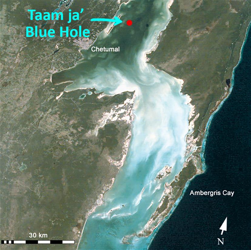
Chetumal Bay is a shallow, tropical estuary some 16.4 feet (5 meters) deep with nearby lagoon systems, underground springs, and idyllic cenotes—those paradisiacal sinkhole pools in the jungle that have become so trendy among travelers. One system of cenotes near the Mexico-Belize border was found to have water depths of 131-295 feet (40-90 meters).

What might be causing land and seabed to sink in this way, you ask?

Blue holes, cenotes, submarine caves, and the like—they all result from repeated flooding and draining of seawater over limestone. The sea-level oscillations that occurred during and after the ice age caused highly saline waters to penetrate the highly-porous limestone along the Yucatán coast. This enhanced the development of voids within the rock, resulting in geomorphic phenomena known as karst formations. They are found throughout the peninsula, and local fishermen offered tips to researchers about the one in Chetumal Bay.

Figure 1: Location of Taam ja’ Blue Hole inside Chetumal Bay: (A) Surrounding sinkholes or cenotes along Laguna Bacalar and the reported locations for the blue holes, poza A and poza B, within Chetumal Bay, near the Mexico-Belize border; and (B) contour levels overlapped over underwater imagery of the blue hole obtained from georeferenced raster images taken by side-scan sonar recordings. (<a href="https://www.frontiersin.org/articles/10.3389/fmars.2023.1141160/full">© 2023 Alcérreca-Huerta, Álvarez-Legorreta, Carrillo, Flórez-Franco, Reyes-Mendoza and Sánchez-Sánchez</a>/CC BY 4.0)
Figure 1: Location of Taam ja’ Blue Hole inside Chetumal Bay: (A) Surrounding sinkholes or cenotes along Laguna Bacalar and the reported locations for the blue holes, poza A and poza B, within Chetumal Bay, near the Mexico-Belize border; and (B) contour levels overlapped over underwater imagery of the blue hole obtained from georeferenced raster images taken by side-scan sonar recordings. (© 2023 Alcérreca-Huerta, Álvarez-Legorreta, Carrillo, Flórez-Franco, Reyes-Mendoza and Sánchez-Sánchez/CC BY 4.0)

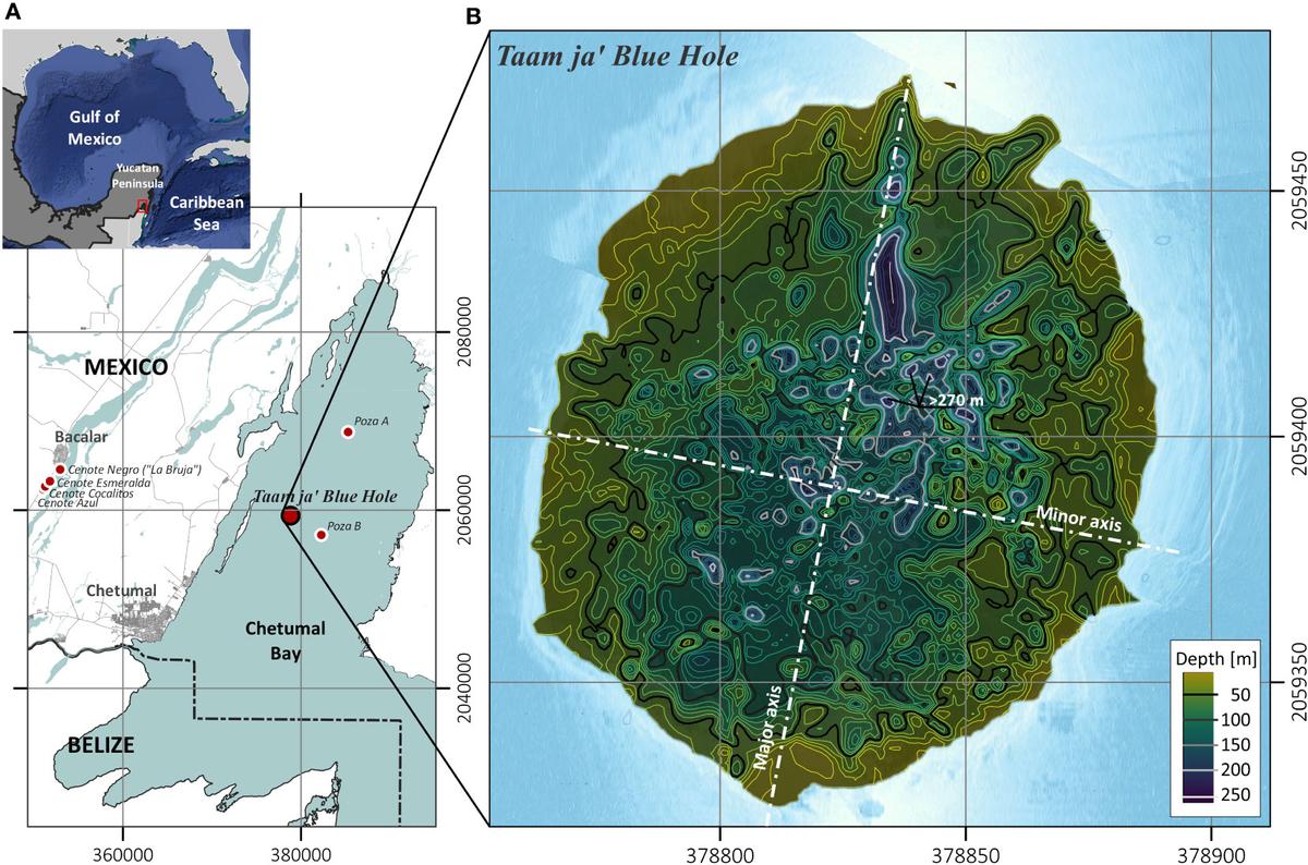
Field work began in 2001. Smack dab in the center of Chetumal Bay, with very shallow, tropical waters all around, they identified a near-circular perimeter with irregular rocky ledges lining what was found to be a steep slope puncturing the flat estuary.

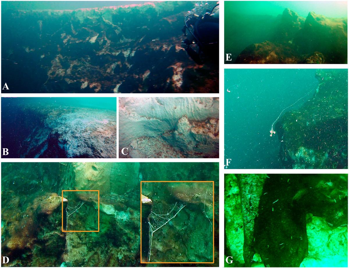
A series of discontinuous terraces were detected near the eastern and northwestern walls which developed into almost-vertical slopes. The southwestern wall was even steeper. Scuba divers descended along the south-southeastern wall, eventually reaching a depth of 656 feet (200 meters).

Figure 2: (A) 3D morphological map of Taam ja’ Blue Hole starting at the seabed of Chetumal Bay descending to a depth of 274.4 meters depth; (B) Aerial drone image of the blue hole, seabed features surrounding the entrance of the blue hole and size comparison with a boat 8.5 meters in length; (C) Subaquatic view of the mouth of the hole from 20 meters deep oriented along the southern wall. (<a href="https://www.frontiersin.org/articles/10.3389/fmars.2023.1141160/full">© 2023 Alcérreca-Huerta, Álvarez-Legorreta, Carrillo, Flórez-Franco, Reyes-Mendoza and Sánchez-Sánchez</a>/CC BY 4.0)
Figure 2: (A) 3D morphological map of Taam ja’ Blue Hole starting at the seabed of Chetumal Bay descending to a depth of 274.4 meters depth; (B) Aerial drone image of the blue hole, seabed features surrounding the entrance of the blue hole and size comparison with a boat 8.5 meters in length; (C) Subaquatic view of the mouth of the hole from 20 meters deep oriented along the southern wall. (© 2023 Alcérreca-Huerta, Álvarez-Legorreta, Carrillo, Flórez-Franco, Reyes-Mendoza and Sánchez-Sánchez/CC BY 4.0)

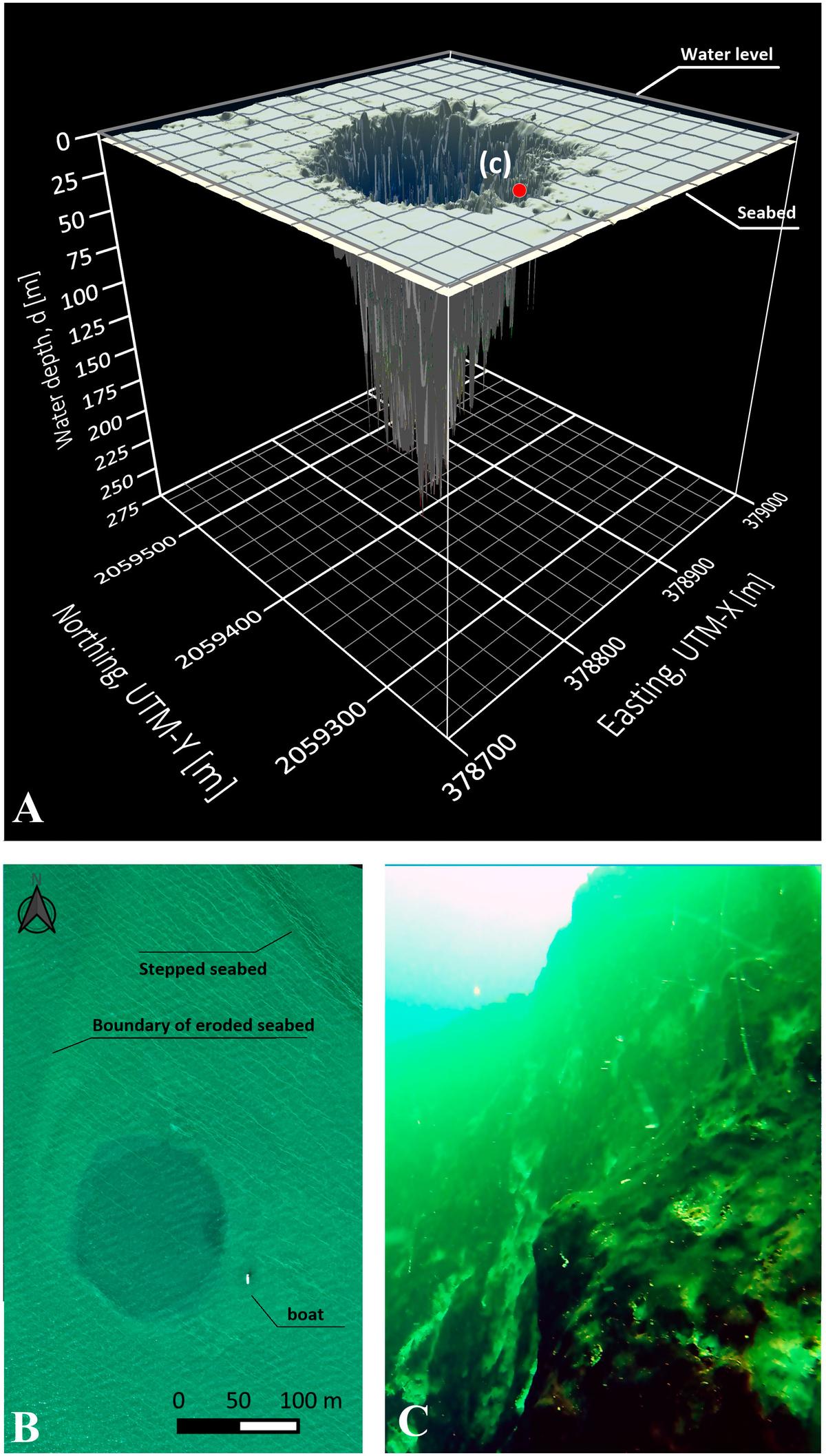
They used side-scanning sonar to map the blue hole’s morphometric features (shape and size) and determined it to have an external perimeter of 1616.4 feet (492.7 meters) with a surface area of 44,914 feet (13,690 meters). It is roughly conic in shape, though north-skewed, while what was determined to be its major axis is oriented similarly to geological faults in the region.

They also collected water samples at intervals from various depths.

The blue hole’s water column characteristics were found to be similar to those of other blue holes, such as Dragon Hole and Amberjack Hole, in the Gulf of Mexico; temperatures decreased with depth while salinity increased. All displayed an anoxic—low oxygen—deep water layer. Taam ja’ also exhibited physiochemical features such as a deep-water detrital layer that allowed only minimal light penetration, forcing divers to carry artificial lights. They found concentrations of sulphate, chlorine, and chlorophyll-a, which also increased with depth.

Figure 3: Insights into the morphological and biological features at Taam ja’ Blue Hole; (A, B) Entrance border at the southern wall of the blue hole surrounded by a flat limestone platform, which is part of the Chetumal Bay seabed; (C, D) Exposed white patches of limestone from rockslides are intercalated with biofilms and (E) limestone rocky ledges of 2-3 meters; (D, F) Detail of mucoid filaments floating in the waters of the blue hole and attached to its walls; and (G) worms and biofilms covering exposed limestone over which dead barnacles were observed. (<a href="https://www.frontiersin.org/articles/10.3389/fmars.2023.1141160/full">© 2023 Alcérreca-Huerta, Álvarez-Legorreta, Carrillo, Flórez-Franco, Reyes-Mendoza and Sánchez-Sánchez</a>/CC BY 4.0)
Figure 3: Insights into the morphological and biological features at Taam ja’ Blue Hole; (A, B) Entrance border at the southern wall of the blue hole surrounded by a flat limestone platform, which is part of the Chetumal Bay seabed; (C, D) Exposed white patches of limestone from rockslides are intercalated with biofilms and (E) limestone rocky ledges of 2-3 meters; (D, F) Detail of mucoid filaments floating in the waters of the blue hole and attached to its walls; and (G) worms and biofilms covering exposed limestone over which dead barnacles were observed. (© 2023 Alcérreca-Huerta, Álvarez-Legorreta, Carrillo, Flórez-Franco, Reyes-Mendoza and Sánchez-Sánchez/CC BY 4.0)
Often, blue holes are hotbeds for biodiversity where corals, sharks, and sea turtles thrive. The researchers who investigated Taam ja’ in 2021 found none of those but found biofilm on its exposed limestone, gypsum-covered walls, mucoid filaments, and worms no larger than an inch or so.

The blue hole offers an opportunity to understand how life existed eons ago, as the anoxic environment preserves its contents from decay.

“These karst features are relevant to marine scientific research as they represent repositories of paleoenvironmental and paleoclimate information that enhance the understanding of environmental … and geologic processes,” the authors wrote in their study, published on February 23 in journal Frontiers.

The world’s second-deepest blue hole is a window into the past.

Theirs was the first foray into Taam ja’ Blue Hole and was far from exhaustive, the researchers stated. They recommend that investigations continue into the formation’s microbial diversity, water and mineral compositions, and other avenues. For now, Taam ja’ remains unknown to the public, they added. There is no better time for exploration than the present.

Share your stories with us at [email protected], and continue to get your daily dose of inspiration by signing up for the Inspired newsletter at TheEpochTimes.com/newsletter
Michael Wing is a writer and editor based in Calgary, Canada, where he was born and educated in the arts. He writes mainly on culture, human interest, and trending news.
Related Topics