The ancient Greeks considered the stars as celestial beings who made their home in the night sky: a great bear, a fish, a winged horse, Perseus holding the head of the Gorgon, and even Hercules shined above the earth every night. Artists and scholars in the Renaissance studied what the ancients had discovered about the constellations and made it their own.
The 15th-century city of Nuremberg, Germany, was alive with discoveries in the arts and sciences, including astronomy and astrology. Schools of the natural sciences and technology, outstanding artists’ workshops, commercial firms, and publishing houses found ways in which they could work together to expand knowledge and technical skills and produce works of outstanding beauty.
But printing brought map-making to Europe. In 1471, Regiomontanus, a German mathematician, astronomer, and astrologer, joined with humanist and merchant Bernard Walther to establish the first scientific printing press, from which he published a five-book astrological poem “Astronomica” by Marcus Manilius.
Johannes Stabius (circa 1460–1522) initiated the project of a star map. An Austrian mathematician and cartographer, Stabius designed the projection of the charts. German astronomer Konrad Heinfogel numbered and plotted each constellation for the map.
This project inspired the emerging titan of the German Renaissance, Albrecht Dürer, to add his genius to the mix. Dürer worked with the scientist and map-maker to complete the images and produce a celestial map, both beautiful and scientifically correct.
Dürer’s Star Map
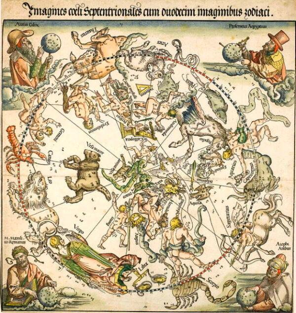
Dürer titles his map in Latin: “Imagines coeli septentrionales cum duodecim imaginibus zodiari” (“The Northern Celestial Hemisphere With Images of the Zodiac”). Although square, Dürer’s star map radiates in a circular fashion from the inside moving outward, crowned with the constellation gods moving within the central space. The map features 48 constellations based on Ptolemy’s ancient star map. This was the first time that the stars were accurately placed based on scientific coordinates. Slices of the pie formed the zodiac around the stars. Each zodiac symbol, to be read counterclockwise, was depicted as drawn figures in an ancient manner, as only Dürer could do.Although Dürer did original drawings in their correct placement, he borrowed from a hand-drawn map made in Vienna in about 1440 and another in 1503 by Heinfogel.
Dürer studied ancient literature of star maps and, in each corner of his map, honored four who wrote about the stars. The top left corner of the map shows Aratus Cilix, who wrote the astronomical poem “Phaenomena” on the constellations in the fourth century B.C. Ptolemy, who published a star catalog in ancient times, is placed in the top right corner. On the bottom left, early-first-century Roman astrologer Marcus Manilius wrote stories about the constellations. On the bottom right, the 10th-century Persian astronomer al-Sufi is depicted; he wrote “The Book of Fixed Stars,” a well-known star catalog in Dürer’s day.
The map, due to multiple copies being available and Dürer’s considerable reputation, had great influence throughout Europe, especially within the scientific community. A German, Peter Apian, developed a planisphere (a star chart computer instrument), complete with a carrying handle. Two Dutch cartographers copied Durer’s map on a celestial globe, a round object showing the accurate position of the stars.
Dürer hand-colored only three of his star map prints, two of which were sold at a Sotheby’s auction in March 2011 for $578,543. Dürer also created a similar star map of the southern constellations.
Dürer and his collaborators had learned much from their ancient forebears and, with an accurate map of the northern sky, took the collaboration of science and art to the next level.