Washington County, Maryland, was established in 1776. It was named for the Revolutionary War general who became the first U.S. president. For many years, a bridge over a small creek in that county served people between the farming communities of Sharpsburg and Rohrersville. But when Confederate and Union soldiers met there Sept. 17, 1862, there were major historical implications. The name of what was called Rohrbach (or Lower) Bridge crossing Antietam Creek changed forever.
Finding this tucked-away locale isn’t easy; it’s not often on travelers’ radars. Burnside Bridge now sits on property owned and managed by the National Park Service, thanks to the formation of Antietam National Battlefield in 1890. It’s situated away from the cemetery, Sunken Road, cornfield, and woods where the bloodiest single day of fighting of the entire Civil War occurred.

Bloody Burnside’s Story
The bridge is worth finding not only to read about and understand the historical events that transpired there, but also to experience the picturesque setting the way it must have been prior to three hours of fighting on that fateful day.The drive through the 3,000-plus-acre park takes visitors past preserved farmlands and a few historic farmhouses; but seemingly hidden in a pastoral valley is a charming three-arched, 125-foot-long bridge. Constructed of locally quarried limestone by farmers in 1836, the design was the brainchild of a 19th-century master bridge builder named John Weaver.
The bridge crosses the slow-moving Antietam Creek, a 41.7-mile-long tributary of the Potomac River. On either side of the bridge are fields, but lining the creek are sycamore trees primarily, one of which—near the bridge—was only a 5-foot, few-years-old sapling during the 1862 battle. This impressive tree is now a towering and protected “witness” tree. American Battlefield Trust deems “witness trees are those flora of historic landscapes that remain in place decades or even centuries after noteworthy events unfolded there.”

What the tree “observed” began around 10 a.m. on that autumn day. Roughly 500 Confederate soldiers from Georgia under the command of Confederate Gen. Robert Toombs clashed with the much larger Ninth Corps’ Union force of approximately 5,200 under the command of Gen. Ambrose Burnside. Three attacks occurred, one at about 10 a.m. and another around 11 a.m., according to detailed signage on the east side of the bridge. By the last attack at 1 p.m., Toombs’s men retreated from the bridge, which was captured by the Union.
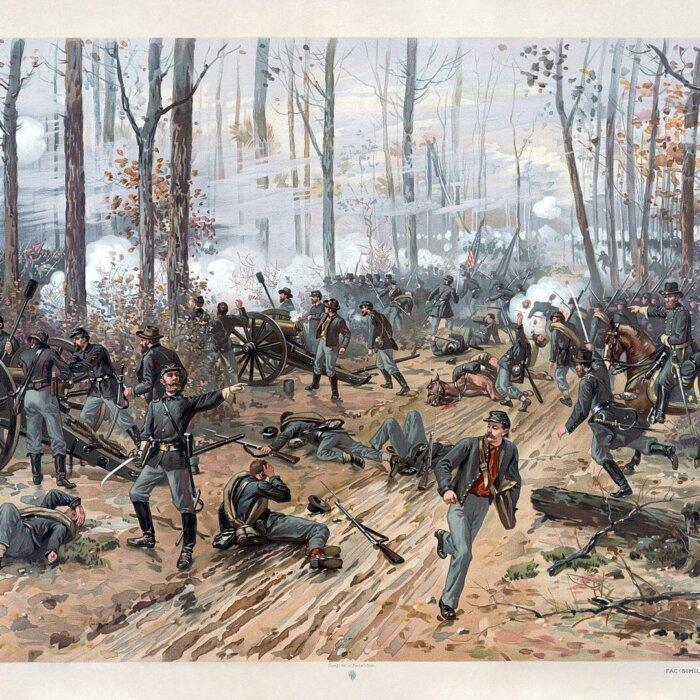

Losses were great, with a Pvt. George Lewis Bronson of the 11th Connecticut Infantry, commenting afterwards: “I do not know the name of the creek, but I have named it the creek of death. Such a slaughter I hope never to witness again.”
Before being reinterred into the Antietam National Cemetery in Sharpsburg or to other locations, men were buried temporarily at the base of the stone wall that runs along a section of the east side of the bridge. Planks laid atop both sides of the stone bridge were pulled off and used for headstones. The planks have since been replaced.
On what the fighting soldiers referred to as the “bridge of destiny,” casualties were high. There were 500 Union soldiers and 120 Confederate soldiers either killed, wounded, or missing. Immediately after the battle, everyone in the community and on the Union side began referring to the bridge as Burnside Bridge and the name stuck.

Today, the beauty of the pristine setting belies what once occurred on and around the bridge. On a recent November 2024 visit of Burnside Bridge, 162 years after southern and northern Americans fought with one another, my dog waded into the clear Antietam creek and rolled in the fields thick with green grass while the brilliant blue sky caused the looming, over 150-year-old sycamore to cast shadows on the bridge’s surface—where men fought and died.