Have you ever dreamed of climbing Mount Everest? How about diving in the depths of a crystal clear ocean, or walking in spring under the blooming cherry trees in Japan?
It’s sometimes hard to break from daily routines to do something out of the ordinary, let alone visiting some of the most astounding—and remote—locations in the world. Those places are normally reserved for the luckiest, and often the most courageous, of people.
Some of the world’s most beautiful locations are accessible, however, from the comfort of your armchair and for free. Thanks to Google Street View, it’s as easy as reading this article.
Here are 10 of the world’s most amazing places shown by Google Street View.
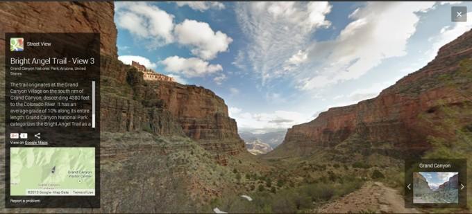
1. Grand Canyon and the Colorado River
Google Trekker cameras went on an adventurous tour of the Grand Canyon, bringing viewers full 360-degree views of more than 75 miles of trails and surrounding roads.
An official Google blog post states: “You'll be happy you’re virtually hiking once you get to the steep inclines of the South Kaibab Trail.” The South Kaibab Trail is the Canyon’s hardest trek.

(Google Maps)
2. Amazon Rainforest in Brazil
The Amazon River, running through the Amazon rainforest, is the largest river in the world. The Amazon rainforest is home to millions of species, and biologists are continually discovering more.
With Street View, you charge through the forest’s wild paths and explore one of the world’s most dangerous places from the comfort and safety of home.

(Google Maps)
3. Mount Everest, Himalayas
On our Street View world tour, now we travel to the highest peak of the world!
Everest rises 29,029 feet (8,848 meters) above sea level—and it is still growing, thanks to lithospheric plate movements.

(Google Maps)
4. Galapagos Islands
The Galapagos Islands, officially called Archipiélago de Colón, were formed from lava, which makes them look like drops rising from the blue waves of Pacific Ocean. The total land area of these 19 islands is 3,093 square miles (8,010 square kilometers). They are scattered over 23,000 square miles (59,500 square km) of ocean.
They are now a UNESCO World Heritage Site.

(Google Maps)
5. Shark Bay, Australia
The name of this famous bay is certainly fitting.
An early account of numerous sharks swimming in the bay was provided by Pirate William Dampier in the 17th century.
Not only are many sharks readily observed in the bay, but also whales, the largest and richest sea-grass beds in the world, and dome-shaped deposits formed by algae that are among the oldest forms of life in the world.

(Google Maps)
6. Japanese Cherry Trees
Now on to a site that is close to Shark Bay geographically, but worlds away culturally. With a click, we find ourselves under Japan’s cherry trees in full blossom.
Google put together colorful panoramas of multiple Japanese cherry tree parks, all accessible under a single cherry blossom section in Street View.

(Google Maps)
7. Antarctic Penguins
Polar bears and penguins can never meet, since the bears live in the Arctic and penguins live in the Antarctic—quite a distance apart.
You, however, can virtually tread where both live with extraordinary Street Views of the frozen lands.
The Antarctic is the fifth largest continent, and its name means “opposite to the Arctic.”

(Google Maps)
8. Mont Blanc, Alps
Our Street View world tour brings us to another snowy peak, this time in the European Alps. Mont Blanc is the highest peak in the Alps, at 15,771 feet (4,807 meters) above sea level.
It is at the intersection of the Swiss, French, and Italian borders, so standing at the top means a little sneak peek into all three countries.

(Google Maps)
9. Great Barrier Reef, Australia
The Great Barrier Reef, which has been described as a “natural sculpture” of great beauty, is also the world’s largest structure composed of living creatures.
A 2012 Google blog post proudly declares: “You don’t have to know how to swim to explore and experience six of the ocean’s most incredible living coral reefs, which are ranging on 135,000 square miles (350,000 square kilometers).”

(Google Maps)
10. Mount Fuji, Japan
Now we travel back to the Japan to visit a new UNESCO World Heritage Site. Mount Fuji was declared a World Heritage Site earlier this year. You can explore the mountain, 12,388 feet (776 meters) above sea level, that has inspired countless haikus and traditional prints—not just the famed “Great Wave off Kanagawa.”
Travel straight to the peak without all the climbing with Street Views.

(Google Maps)
11-26-13


