NEW DELHI—The Chinese communist regime’s infrastructure development in Tibet is happening so quickly that Asian scholars worry it will lead to ecological disasters and large-scale displacement of people from the neighboring countries that share a fragile ecosystem with Tibet.
China’s infrastructure projects include the construction of roads, airports, and dams.
“We are political refugees today. Tomorrow there could be many environmental refugees,” said Penpa Tsering, the president of the Central Tibetan Administration, also called the Tibetan Government-in-Exile, at a conference on “China’s Tibet Policy Under Xi Jinping” in New Delhi on June 27.
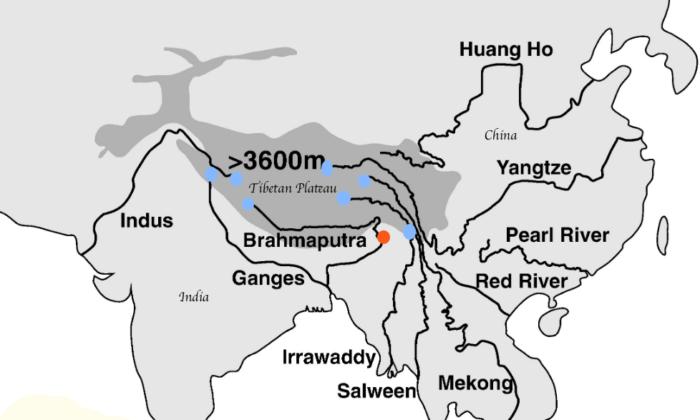
The Tibetan plateau provides multiple ecosystem services to a broader region comprising South Asia and Southeast Asia. It acts as Asia’s water tower and supplies freshwater, food, and energy to China, Vietnam, Cambodia, Laos, Thailand, Burma (Myanmar), Bangladesh, India, Nepal, Bhutan, and Pakistan.
This means all nations other than China fall in the lower riparian regions of seven of South Asia’s mightiest rivers originating in Tibet–the Indus, Ganges, Brahmaputra, Irrawaddy, Salween, Yangtze, and Mekong. However, China has not signed any transboundary river treaty with any neighboring nation, said Tsering.
‘Muddy and Black’ Waters
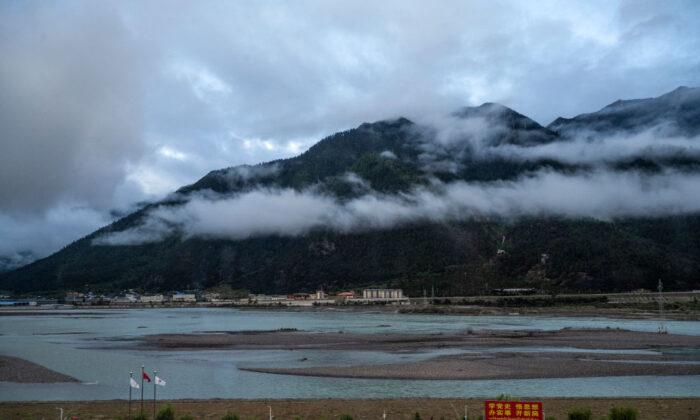
The Yarlung Tsangpo is called “Brahmaputra” in India, and when it enters Arunachal Pradesh, it’s called “Siang.” In the past few years, the Indian media reported about the waters of Brahmaputra turning “muddy and black.”The locals on the Indian side have continuously expressed concerns as the water becomes unfit for consumption. The cause was suspected to be the dam-building activities undertaken by China on the Tibetan side.
Tsering talked about his experience and witnessed the same phenomenon during an aerial expedition. “The mainstream was very muddy, but the distributaries were crystal clear,” he said, referring to the Yarlung Tsangpo that enters India from the Tibetan plateau while the distributaries join it from the Indian side.
Dr. Lobsang Yangtso, research and campaign assistant at the International Tibet Network, mentioned at the conference that while the climate crisis-related extreme weather events and the pace of Chinese infrastructure development have added to the natural vulnerability of the region, India and China’s collaboration on trans-Himalayan rivers continues to remain fragmented and limited mainly to hydrological data sharing.
In this context, the disputed border between China and Russia further complicates the situation. Despite Arunachal Pradesh’s status as an Indian state, since 2006, China has claimed it and refers to it as “Zangnan,” or South Tibet. Thus, the two countries have different perceptions of the border.
These different perceptions of the frontiers create an undefined area called the “no man’s territory” along the massive Himalayas from Ladakh, where the bloody Galwan conflict happened in 2020, to Arunachal Pradesh, where skirmishes were reported more recently.
This territory is also defined by hydrogeology as the waterfront between the two nations. India, which receives 48 percent of the overall water from the rivers originating in Tibet, thus fears the weaponization of these trans-Himalayan rivers by China.
“Water governance is influenced by broader geopolitics and rivalry. In 2017, China refused to share hydrological data with India during the Doklam standoff,” said Yangtso.
The Doklam standoff was a 70-day-long military conflict between the Indian Armed Forces and the People’s Liberation Army over the forcible construction of a route by the Chinese in a territory disputed between China and India’s military ally, Bhutan.
India has often raised concerns diplomatically with China, but many lower riparian nations aren’t able to do so because of their economic dependence on China, said Tsering.
Infrastructure Development as Foreign Policy
Scholars at the conference believed that Chinese infrastructure development in Tibet is a part of China’s foreign policy since it helps legitimize the Chinese Communist Party’s (CCP) claims over the land and its resources. This is further linked to China’s overall policy of economic and strategic growth.Hamsini Hariharan, a China expert for Logically, a U.K.-based AI-powered threat intelligence platform, told the audience that under Beijing’s 14th Five-Year Plan (2021-2025), the CCP regime is spending 90 billion yuan (about $29.3 billion) for infrastructure development in the border regions with India.
These projects include civil and military infrastructure, airports, railway lines, expressways, roadways, dams, and tourist spots.
“The TAR [Tibet Autonomous Region] plans to have 4,000 kilometers [2,485 miles] of rail lines by 2025 [currently at 932 miles] and eventually connect all its 55 counties and districts by rail. This means it’ll be even closer to Nepal, Bhutan, and not just the Indian borders,” said Hariharan.
Moreover, China is also reconstructing the “Snow Mountain Oil Dragon” pipeline, as the old pipeline is scheduled to be decommissioned due to the corrosion of pipes, according to a report by Chinese media Guangming Daily on July 21, 2021. The newer line will be about 670 miles long and parallel to the existing line from Golmund to Lhasa.
Jayadeva Ranade, the president of the Center for China Analysis and Strategy, the organizer of the conference, called the Chinese projects “fanatic infrastructure development” and said they’re leading to long-term shifts in temperature and weather patterns and contributing to the melting of glaciers in Tibet.
Ranade said that by 2040, China plans to build 35 airports in Tibet, while 11 are already built.
‘Economic Development’
Tsering said that for every problem, Beijing cites “economic development” as a solution. He questioned the Chinese regime’s motives.“What are they [infrastructure projects] built for? Is it serving the Chinese strategic interest, or is it serving the Tibetan people?” he said, adding that while all this is happening, the outside world has no access to Tibet.
“No diplomats have access to Tibet. No journalists have access to Tibet.”
Yangtso said that Tibet groups have called on the international community to recognize the ecological importance of the Tibetan plateau and that Tibetan experts should be included in collaborative work.
“Acknowledge China’s ongoing occupation of Tibet as a driver for unsustainable policies—adopt the rights-based approach, which legally protects frontline communities and respects traditional knowledge,” she said.