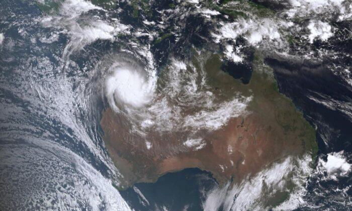
Australia is currently monitoring its most severe storm in years as Severe Tropical Cyclone Ilsa has intensified into a Category 5 system, the highest level on the scale measuring cyclone strength.
Ilsa is projected to make cross the coast in Western Australia (WA) as one of the most powerful cyclones to make landfall in the region later Thursday night local time.
The cyclone is expected to have wind speeds reaching up to 285 kilometers (177 miles) per hour.
The bureau advised that the impact of the storm would be severe and that it would affect the coastal and adjacent inland areas east of Port Hedland and west of Wallal Downs. The storm is expected to hit the largely unpopulated region, most likely between Pardoo Roadhouse and Wallal Downs, either late at night on Thursday or early on Friday morning.
According to a BOM advisory, the core of Ilsa is anticipated to be extremely destructive, with gusts of up to 285 kilometers (177 miles) per hour. It is expected to impact the region between De Grey and west of Bidyadanga late on Thursday night or early on Friday morning before moving inland.
On Friday, “very destructive” wind gusts up to 170 kilometers (105 miles) per hour are possible at Telfer if the storm’s eye passes close by, according to BOM.
‘Get Ready to Shelter’
The BOM asked residents between Bidyadanga and Whim Creek, including Port Hedland extending inland to include Marble Bar, Nullagine, and Telfer, “to act and get ready to shelter from a cyclone.”
In addition to the upgraded warning, BOM has advised residents in certain areas to take necessary precautions and prepare for the impact of the storm.
Those residing south of Broome to Bidyadanga, excluding Bidyadanga, as well as the inland regions extending up to Parnngurr and Kiwirrkurra, have been instructed to get ready for cyclonic weather conditions. BOM has recommended that residents in these areas should prepare an emergency kit containing essential items such as a first aid kit, portable radio, torch, spare batteries, food, and water.
BOM’s Todd Smith said an automated weather station at Rowley Shoals, an island 260 kilometers (161 miles) west of Broome had already recorded wind gusts up to 235 kilometers per hour, reported the ABC.“So we know that this system is really packing a punch,” Smith said.
“Category five cyclones are incredibly dangerous, with wind gusts in excess of 250 kilometers per hour. That’s going to cause a heap of damage to trees, vegetation; if there were any caravans around, they would be destroyed,” he added.
“Any houses that aren’t built to code are going to suffer extensive damage from that kind of wind strength,” he added.
Residents Prepare
According to a report by AAP, Will Batth, who manages the fueling station at Pardoo Roadhouse, where the cyclone is expected to hit, has decided to stay back and wait out the storm with a colleague.“We haven’t had any as strong as this in many years. This is a big one,” he said.
Batth noted that there were a few cars still travelling on WA’s North West Coastal Highway, but the roadhouse was now closed for business, with most of the staff evacuating to Port Hedland.
Meanwhile, Port Hedland Mayor Peter Carter said an eerie quiet had descended over the town of 16,000 as residents prepared for the cyclone’s impact.
“What’s happening with this cyclone is very unusual, and a lot of people are getting very worried because it’s getting closer and closer to Port Hedland,” he said.
“At the moment, it’s very quiet, but this thing is supposed to hit us in 14 hours (and) that could change again,” he added.
“The longer it stays out in the ocean, the bigger it’s going to get (and) the more powerful it’s going to get,” he added.
To ensure the safety of residents who feel that their homes may not withstand the storm, an evacuation center has been established in Port Hedland. Meanwhile, the international port in Port Hedland, which is responsible for exporting iron ore globally, has taken precautions by evacuating all ships to prevent any potential damage in the event of a natural disaster.
“Most infrastructure is designed for cyclones. It’s the flying debris that we worry about,” Carter told AAP.
He added that residents should put away their “wheelie bin” (trash can), barbecue, and gas bottles.
“No one wants them to become missiles,” he added.
The BOM has also warned of abnormally high tides and destructive winds.
The affected area is also likely to experience heavy rainfall, with up to 300 millimeters of rain predicted, as reported by AAP. In light of the situation, workers and tourists from Eighty Mile Beach and Wallal Downs cattle station have already been evacuated.
All non-essential personnel from mining sites across the region, including Newcrest’s Telfer mine, Fortescue Metal Group, and BHP’s mining sites, have been evacuated from their respective locations.


