Tropical Storm Nate Hits Mississippi, Passes Through Alabama as Tropical Depression

Tropical Storm Nate Hits Mississippi, Passes Through Alabama as Tropical Depression
The predicted route of Tropical Depression Nate as of 8 a.m. E.T on Sunday, Oct. 8. (NOAA/ NHC)
Bowen Xiao
10/8/2017
Updated:
10/8/2017

Tropical Storm Nate, downgraded from a hurricane on Saturday, Oct. 7, made landfall in Mississippi on Sunday, bringing flooding and power outages as it came ashore near Biloxi, Mississippi. As of 11 a.m. ET Sunday, Nate was downgraded to a tropical depression.
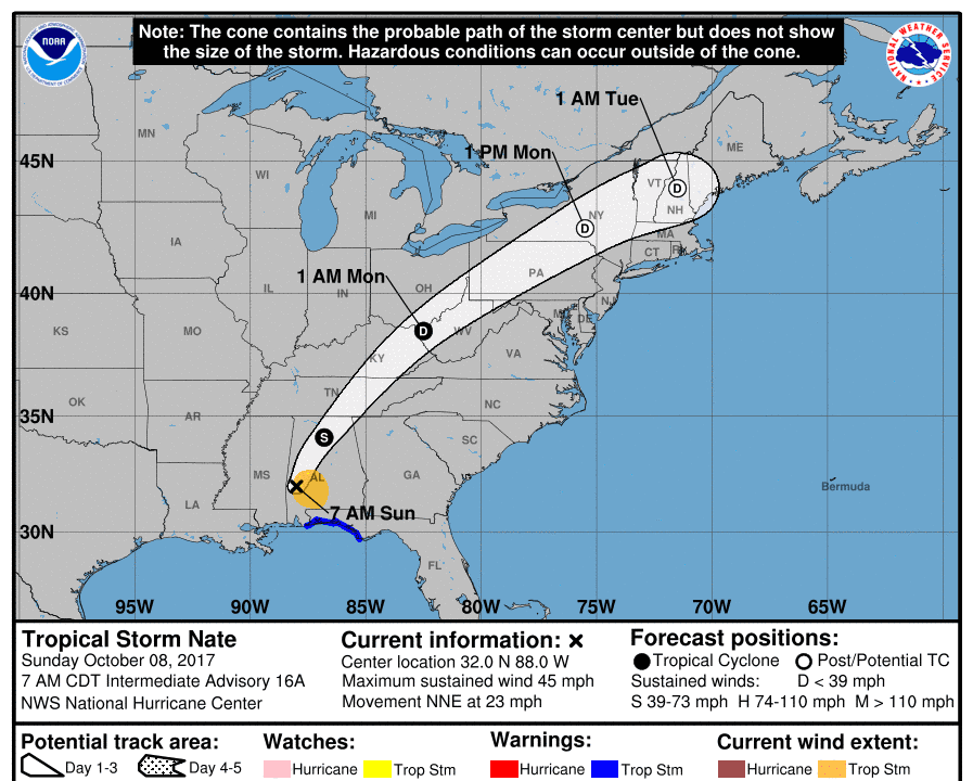
In the same advisory, the NHC said the center of Nate was located about 40 miles southwest of Birmingham, Alabama.

Nate was “rapidly weakening” as it moved inland, but the storm-surge flooding continues to hit the state, according to the National Hurricane Center’s (NHC) 9 a.m ET advisory.

The storm started with maximum winds nearing 85 mph earlier on Sunday, but soon it decreased to 45 mph with higher gusts. Heavy rainfall is predicted to continue to spread over the southeastern area part of the United States, according to the NHC.

The landfall on Sunday was Nate’s second. On Saturday night, the storm came ashore along a sparsely populated area in southeast Louisiana near the Mississippi River.

Nate will likely turn toward the northeast and is expected to increase in forward speed during the next couple of days.

The storm’s powerful winds pushed water onto roads, and knocked out power lines that left many homes and businesses out of power.

No deaths or injuries have been reported in the U.S, but at least 22 deaths have been attributed to Nate in Central America.

Nate’s center will continue to move inland across the Deep South, Tennessee Valley, and the central Appalachian Mountains through Monday.

Water levels remain elevated from storm surge along portions of the northern Gulf Coast, the NHC reported.

It warns that isolated tornadoes are possible today, mainly at the Florida Panhandle and eastern Alabama across western and Northern Georgia and into the western Carolinas.

In Storm Surge Warning areas, water is expected to reach the following heights above ground if the peak surge occurs at the time of high tide, according to the NHC’s 9 a.m. ET advisory: - Mississippi–Alabama border to the Alabama–Florida border, including Mobile Bay, Alabama...5 ft. to 8 ft. - Alabama–Florida border to the Okaloosa County–Walton County line in Florida...3 ft. to 5 ft. - Morgan City, Louisiana, to the Mississippi–Alabama border...1 ft. to 3 ft. - Okaloosa County–Walton County line in Florida to Indian Pass, Florida...2 ft. to 3 ft. - Indian Pass, Florida to Crystal River, Florida...1 ft. to 3 ft.
From NTD.tv
Bowen Xiao was a New York-based reporter at The Epoch Times. He covers national security, human trafficking and U.S. politics.
twitter