Tropical Storm Katia Upgraded to Hurricane Katia

Tropical Storm Katia Upgraded to Hurricane Katia
(NOAA)
Jack Phillips
9/6/2017
Updated:
9/6/2017

Update: Katia is now a Category 1 Hurricane, according to the National Hurricane Center’s latest advisory at 5 p.m. ET.

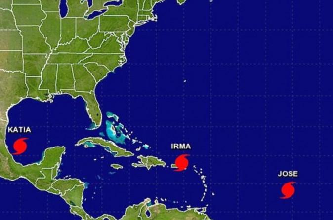
Hurricane Jose and Hurricane Katia formed on Wednesday, the agency stated, according to the 5 p.m. post. (NOAA)


----

Earlier update:

Tropical Storm Katia formed in the Gulf of Mexico, and it may pose a threat to the eastern portion of Mexico.

Katia is expected to strengthen into a hurricane before making landfall in Mexico. It’s about 135 miles east of Tampico and some 175 miles Veracruz, the National Hurricane Center (NHC) said on Wednesday morning, Sept. 6.

It has winds of up to 45 mph, and it is moving east-southeast at 5 mph.

Tropical Storm Katia. (NOAA)

“There are no coastal watches or warnings in effect,” the NHC said, but stipulated, “a hurricane watch could be required for portions of the Mexican state of Veracruz later today.”

The center said that Katia is expected to stay offshore until Friday morning.

(NOAA)
(NOAA)

According to the NHC, here is the 48-hour outlook on Katia:

At 1000 a.m. CDT (1500 UTC), the center of Tropical Storm Katia was located near latitude 21.7 North, longitude 95.9 West. Katia is moving slowly toward the east-southeast near 5 mph, and little motion is expected during the next day or so.

Maximum sustained winds are near 45 mph with higher gusts. Strengthening is forecast and Katia could become a hurricane before it approaches the coast of Veracruz in a couple of days. An Air Force reconnaissance plane will check Katia later today.

Tropical-storm-force winds extend outward up to 45 miles from the center. The estimated minimum central pressure is 1004 mb (29.65 inches).

The hazards include:

Katia is expected to produce total rain accumulations of 5 to 10 inches over northern Veracruz, and 2 to 5 inches over far southern Tamaulipas, northeast Puebla, and southern Veracruz through Saturday morning. Isolated maximum amounts of 15 inches are possible in northern Veracruz. This rainfall may cause life-threatening flash floods and mudslides, especially in areas of mountainous terrain.


Meanwhile, Hurricane Irma is continuing to churn across the Atlantic Ocean, nearing the Caribbean’s northern Leeward Islands, east of Puerto Rico, late on Tuesday, Sept. 5, with maximum sustained winds of 185 miles per hour, Reuters reported.

The U.S. National Hurricane Center (NHC) in Miami forecast the storm would make landfall in Florida on Saturday, although Irma’s precise trajectory is yet to be determined.

Forecasters described the storm as “potentially catastrophic.” Irma ranks as one of the five most powerful Atlantic hurricanes during the past 80 years and is the strongest Atlantic storm ever recorded outside the Caribbean Sea and Gulf of Mexico, the NHC said.

Reuters contributed to this report.


Jack Phillips is a breaking news reporter with 15 years experience who started as a local New York City reporter. Having joined The Epoch Times' news team in 2009, Jack was born and raised near Modesto in California's Central Valley. Follow him on X: https://twitter.com/jackphillips5
twitter