This copy is for your personal, non-commercial use only. Distribution and use of this material are governed by our Subscriber Agreement and by copyright law. For non-personal use or to order multiple copies, please contact The Epoch Times Reprints.
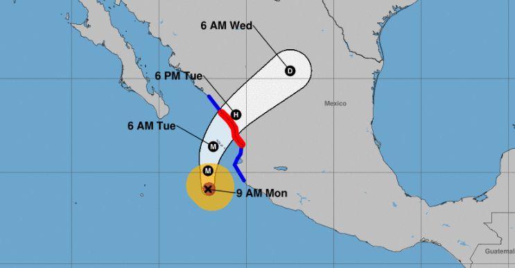
The storm has 155 mph winds after slightly weakening from a Category 5 storm with 160 mph winds. Hurricane Michael had 155 mph winds when it slammed the Florida Panhandle earlier this month, killing at least three dozen people.
Willa is expected to produce life-threatening conditions, including heavy winds, rain, and storm surge along west-central and southwestern Mexico, according to the NHC.
The storm is expected to hit land during midday on Tuesday. Then, the storm’s remnants are forecast to pass over northern and eastern Mexico before possibly hitting southern Texas.
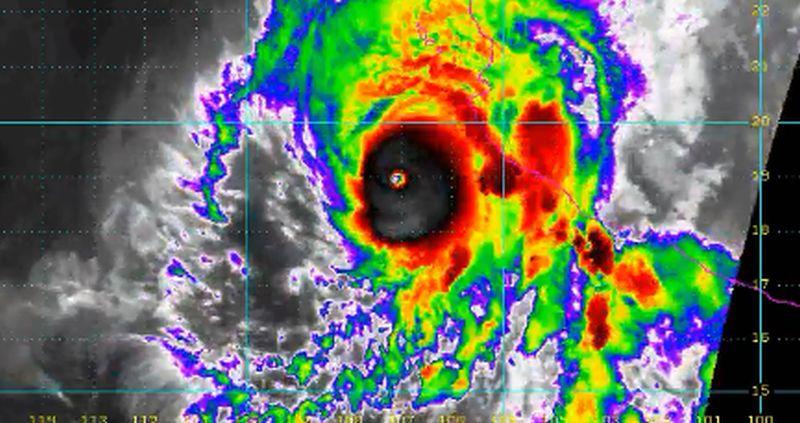
A satellite image taken by NOAA of Hurricane Willa shows the storm off Mexico on Oct. 22. NOAA
San Blas to Mazatlan, including Las Islas Marias, are under hurricane warnings while tropical storm warnings were issued for Playa Perula to San Blas and north of Mazatlan to Bahia Tempehuaya.
“Willa is moving toward the north near 8 mph, and this general motion should continue tonight. Willa is forecast to accelerate toward the north-northeast and move over or very near the Islas Marias early Tuesday and make landfall along the west-central coast of mainland Mexico in the hurricane warning area Tuesday afternoon or evening,” reads a discussion of the storm from the NHC.
While the storm has 155 mph winds now, some “weakening is forecast during the next day or so, but Willa is expected to be a dangerous major hurricane when it reaches the coast of Mexico.”
Hurricane Willa strengthened to become a rare Category 5 hurricane and is still forecast to slam into west-central Mexico. NHC
“Rapid weakening is expected after landfall Tuesday night and Wednesday,” according to the agency.
The storm is also forecast to generate “total rainfall accumulations of 6 to 12 inches, with local amounts to 18 inches, across portions of western Jalisco, western Nayarit, and southern Sinaloa in Mexico.” Flash-flooding and landslides should be expected.
Tropical Storm Vicente
To the southeast of Willa is Tropical Storm Vicente, which is weakening and is “barely a tropical storm,” said the NHC in its latest update on Oct. 22. The storm is expected to dissipate soon.
“Vicente is moving toward the west-northwest near 12 mph, and a turn to the northwest is expected later today followed by a turn to the north-northwest on Tuesday. On the forecast track, the center of Vicente is expected to be near the southwestern coast of Mexico on Tuesday,” said the NHC. “Maximum sustained winds have decreased to near 40 mph with higher gusts. Continued weakening is expected, and Vicente is forecast to dissipate within the next day or so.”
Another Tropical Cyclone?
The NHC, in an update on Oct. 22, said that there is an area of low pressure about 800 miles south-southwest of the Baja California Peninsula in Mexico.
“Environmental conditions are expected to be marginally conducive for some gradual development of this system during the next couple of days, but upper-level winds are expected to become unfavorable for development by later this week,” the agency said, adding that there is a 20 percent chance of a tropical cyclone formation in the next five days.
Jack Phillips is a breaking news reporter who covers a range of topics, including politics, U.S., and health news. A father of two, Jack grew up in California's Central Valley. Follow him on X: https://twitter.com/jackphillips5