Hurricane Jose Strengthens to Category 4: NHC

Hurricane Jose Strengthens to Category 4: NHC
A satellite image of Hurricane Jose. (NOAA)
Petr Svab
9/8/2017
Updated:
10/5/2018

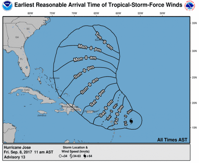
Hurricane Jose has grown in strength and reached Category 4 status—the second highest—as it swipes through the Atlantic Ocean.

Its wind speed increased to 150 mph, and it’s still heading west, according to the U.S. National Hurricane Center in its most recent update on Friday morning (11 a.m. ET, Sept. 8).

It’s moving west-northwest at 18 mph. It’s about 415 miles (670 kilometers) east-southeast of the northern Leeward Islands.

Forecasts as of 11 a.m. EST show that Jose won’t follow the path of Hurricane Irma, which killed at least 12 as it plowed across a string of Caribbean islands.

Still, it prompted hurricane watches on multiple islands in the region Antigua, Barbuda, Anguilla, St. Maarten, St. Martin, and St. Barthelemy. These islands were crushed by Hurricane Irma this week. A hurricane watch means that hurricane force-winds will hit the affected areas within 48 hours.

Irma, which weakened to category 4, is now expected to sideswipe Cuba and will head toward Florida, hitting on Saturday morning.

(NOAA/NHC)
(NOAA/NHC)

A Hurricane Watch is in effect for:
* Antigua, Barbuda, and Anguilla
* Sint Maarten
* St. Martin
* St. Barthelemy

A tropical storm warning is in effect for:
* Antigua, Barbuda, and Anguilla
* St. Martin
* St. Barthelemy
* Sint Maarten

A tropical storm watch is in effect for:
* Montserrat, St Kitts, and Nevis
* Saba and St. Eustatius
* British Virgin Islands
* St. Thomas and St. John

Hurricane Jose is expected, however, to turn northward and miss both the Caribbean nations and the continental United States.

(NOAA/NHC)
(NOAA/NHC)


According to the NHC, here are some of the hazards that might be produced by Jose:

  • For wind, “Hurricane conditions are possible within the hurricane watch area on Saturday, and tropical storm conditions are expected within the tropical storm warning areas by Saturday morning. Tropical storm conditions are possible in the tropical storm watch area in the northeastern Leeward Islands by Saturday morning and in the watch area in the Virgin Islands by Saturday night.”
  • For rainfall, “Jose is expected to produce total rain accumulations of 3 to 5 inches in the Leeward Islands from Guadeloupe to Anguilla, with isolated maximum amounts of 8 inches. Jose is also expected to produce total rain accumulations of 1 to 3 inches over the Virgin Islands and Dominica. This rainfall will maintain any ongoing flooding and may cause additional life-threatening flooding. SURF: Swells generated by Jose are expected to affect portions of the Leeward Islands by later today. These swells are likely to cause life-threatening surf and rip current conditions. Please consult products from your local weather office.
  • And for flooding and surf, “Swells generated by Jose are expected to affect portions of the Leeward Islands by later today. These swells are likely to cause life-threatening surf and rip current conditions. Please consult products from your local weather office.”
Forecast windspeed of Hurricane Jose as of 8 a.m. AST, Sept. 8, 2017. (NOAA)
University of Wisconsin models of Hurricane Jose's possible path as of Sept. 8, 2017, 8 a.m. EST. (University of Wisconsin)