Hurricane Florence Tracker: NASA Posts ‘Stark’ Video of Storm

Jack Phillips
9/12/2018
Updated:
9/12/2018

Hurricane Florence was captured by NASA via the International Space Station, providing a “stark and sobering view” of the Category 4 storm predicted to make landfall in the Southeastern United States.

The footage, according to the space agency, was captured at 7:50 a.m. ET on Sept. 12.

NASA’s “Suomi NPP satellite passed over the eye of powerful Category 4 Hurricane Florence and found the storm over 400 miles in diameter and the capability to generate very heavy rainfall,” according to the agency’s website.

It added: “Florence is about 400 miles in diameter. For an understanding of how large the system is 400 miles is the distance from Baltimore, Maryland to Boston, Massachusetts.”

The satellite’s “infrared imagery showed” that the eye of Florence is “very distinct,” a sign of a powerful storm. “There has been little change to the cloud top temperatures surrounding the eye overnight. The VIIRS imagery also showed that the overall structure has become slightly more symmetric,” according to NASA.

Hurricane Florence was captured by NASA via the International Space Station, providing a “stark and sobering view” of the Category 4 storm predicted to make landfall in the Southeastern United States. (NHC)

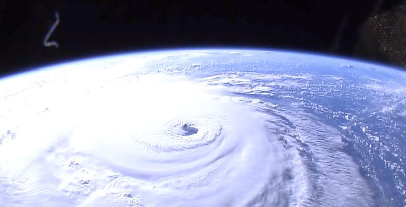
“Florence has a very wide area of storms where cloud tops are colder than that threshold, indicating that the storm has the capability to generate very heavy rainfall over a large area,” the agency also said.

The National Hurricane Center (NHC) has warned that Florence could produce 20 to 30 inches of rain in coastal North Carolina, and western and northern North Carolina could see 5 to 10 inches. Isolated downpours could bring as many as 40 inches of rain in some spots, according to NASA. Elsewhere in the Appalachians as well as Mid-Atlantic states could get 3 to 6 inches of rain.

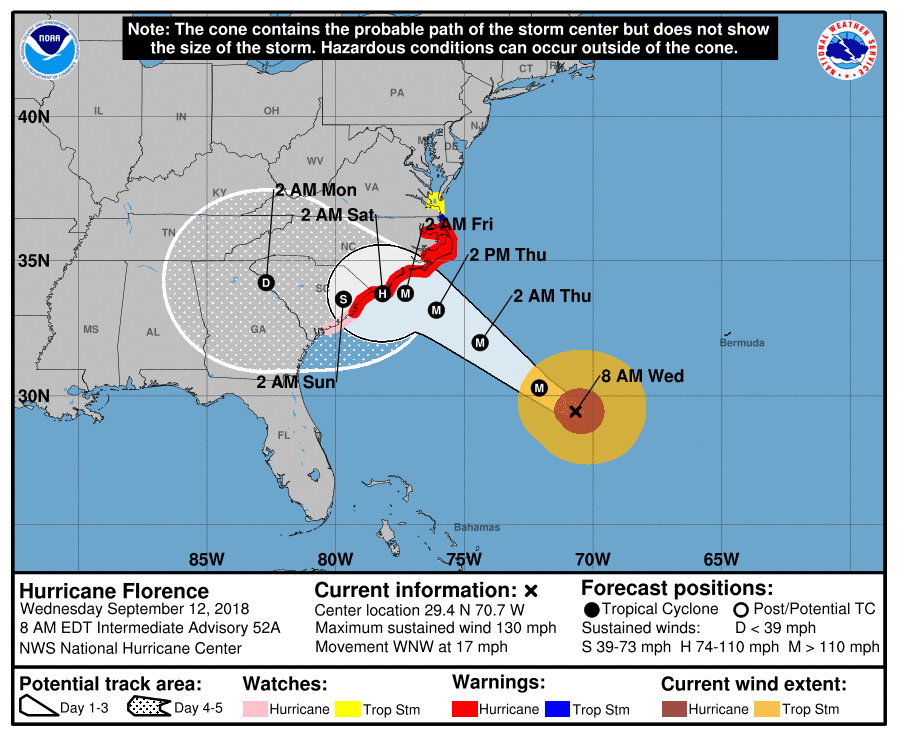
The NHC said the storm has 130 mph winds, making it a Category 4, and some forecasters have said the storm could strengthen before it makes landfall. It is moving northwest at 15 mph, according to the last update at 11 a.m. on Sept. 12.

Warnings and watches are in effect for the entirety of the North Carolina coast and most of the South Carolina coast. Tropical storm warnings are in effect for parts of southern Virginia.

The storm is predicted to also hit Georgia and parts of Alabama. President Donald Trump on Sept. 12 tweeted that residents in Georgia should pay attention to the storm.

“Hurricane Florence may now be dipping a bit south and hitting a portion of the Great State of Georgia. Be ready, be prepared!” President Donald Trump warned on Sept. 12. “Hurricane Florence is looking even bigger than anticipated. It will be arriving soon. FEMA, First Responders and Law Enforcement are supplied and ready. Be safe!” he also wrote.

South Carolina, North Carolina, Virginia, and Maryland have all declared states of emergency. Georgia has not done so.

Officials in Georgia have told local media that they are paying close attention to the storm.

Hurricane warnings were still in effect for the South Santee River, South Carolina, to Duck, North Carolina, and also the Albemarle and Pamlico Sounds. (NHC)

Brief History of Florence

Florence was first dubbed Tropical Depression Six by the NHC, forming near the western coast of Africa,  on Aug. 31. It was later named Tropical Storm Florence the next day as it moved over the eastern Atlantic Ocean.

On Sept. 5, Florence became a Category 4 hurricane after it rapidly intensified over about the span of one day.

It became weakened and was deemed a tropical storm before it went through rapid intensification over the weekend, becoming a Category 4. Some have forecast that the storm could become a Category 5 storm with wind speeds of 157 mph.

Jack Phillips is a breaking news reporter with 15 years experience who started as a local New York City reporter. Having joined The Epoch Times' news team in 2009, Jack was born and raised near Modesto in California's Central Valley. Follow him on X: https://twitter.com/jackphillips5
twitter
Related Topics