Hurricane Florence has picked up strength as it barrels toward the Carolinas, with an expected landfall pushed back to early Saturday.
Damage is also feared across Virginia, Maryland, and Washington, D.C.
“Life-threatening, catastrophic flash flooding and significant river flooding is likely over portions of the Carolinas and Mid-Atlantic states from late this week into early next week,” the center stated in a 5 a.m. update that said the storm was approximately 580 miles southeast of Wilmington, North Carolina.
Wind speeds in the eye of Florence reached nearly 150 miles per hour just after midnight on September 12, according to data recorded by an Air Force aircraft hovering over the hurricane.
While the hurricane is expected to weaken as it begins to interact with land before making landfall, Florence will remain a dangerous major hurricane as it approaches the East Coast, officials said.
Weather conditions are now projected to slow down Florence enough that landfall won’t occur until early Saturday morning.
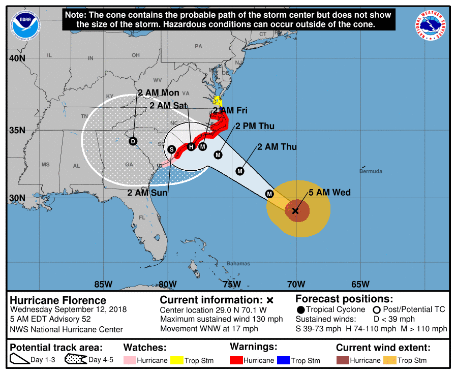
The storm is currently classified as a “major hurricane”, meaning wind speeds are greater than 110 miles per hour.
At the time of landfall, the storm is forecast to be classified as a “hurricane”, with speeds between 74 miles per hour and 110 miles per hour.
Still, high winds will potentially inflict severe or complete damage to buildings, snap tree limbs or even uproot them, and knock power and water lines out.
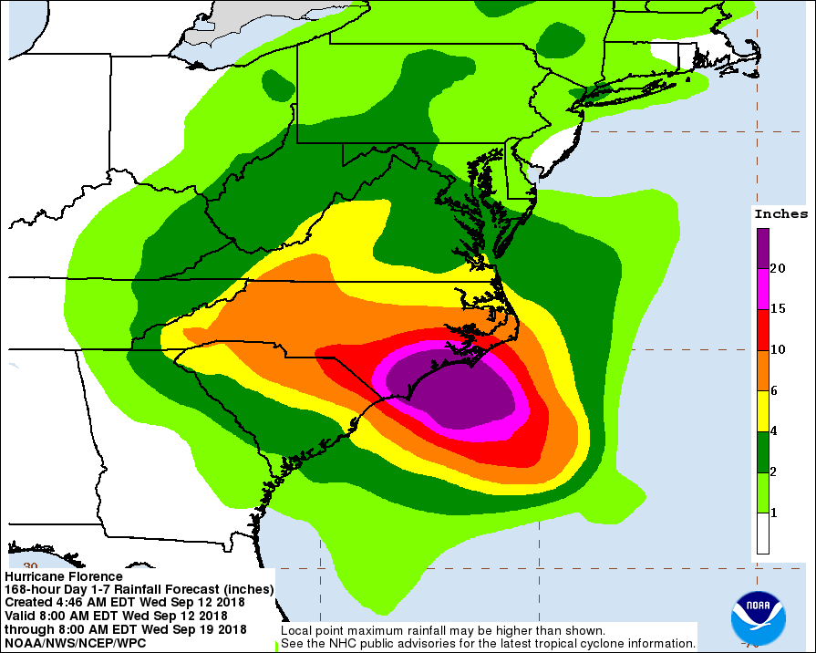
Rainfall of over 20 inches within the next week is projected, with some pockets possibly getting 35 inches or more.
What Scares Experts About Hurricane Florence
To whip up a monstrous storm like the one chugging for the Carolinas you need a handful of ingredients—warmer than normal sea temperatures; a wind pattern that allows a storm to get strong and stay strong; higher sea levels; and a storm covering an enormous area—and Florence has them all.In addition, a high-pressure ridge that’s parked over the East Coast is expected to prevent Florence from doing the typical swerve away from the Carolinas and also keep it stuck for multiple days once it reaches land.
“The longer it stays, the more wind, the more rain. That means the more trees that could fall, the more power outages,” National Hurricane Center Director Ken Graham said.
“This one really scares me,” Graham said. “It’s one of those situations where you’re going to get heavy rain, catastrophic, life-threatening storm surge, and also the winds.”
The National Hurricane Center Tuesday afternoon increased its rainfall forecast to 15-25 inches of rain with 35 inches in isolated spots.
But a computer simulation known as the European model predicts some places could get 45 inches. Sound unlikely? It’s the same model that accurately predicted that last year’s Hurricane Harvey, which also stalled over land, would drop 60 inches.
“It does look a bit similar to Harvey in a sense that it goes roaring into shore and then comes to a screeching stop,” said MIT meteorology professor and hurricane expert Kerry Emanuel. “This is not a pretty sight.”
After Florence makes landfall, the high-pressure ridge, now over Washington and New York, will move east, but be replaced by another one forming over the Great Lakes that will likely keep the storm stuck, according to University of Miami hurricane expert Brian McNoldy.
Florence’s path remains uncertain. It may move a little north into Virginia or a little south into South Carolina. But it’s such a large storm that the rain will keep coming down in the region no matter where it wanders. And with the Appalachian Mountains to the west, there could be flooding and mudslides, experts worry.