This copy is for your personal, non-commercial use only. Distribution and use of this material are governed by our Subscriber Agreement and by copyright law. For non-personal use or to order multiple copies, please contact The Epoch Times Reprints.
Wildfires in B.C. are causing air quality issues in Vancouver, visibility issues on highways, and have led to multiple evacuation orders and alerts in the province.
Air quality warnings have been issued for Metro Vancouver and other regions due to smoke from wildfires. According to IQAir, which tracks air quality, the air in Vancouver was 8.5 times higher than the World Health Organization’s global air quality guideline on the morning of Sept. 12.
B.C. government statistics show that since late August there have been six large wildfires in the province, half suspected to be started by humans and half by lightning. B.C. has had almost 1,500 wildfires so far this year, which have burned over 86,000 hectares.
Battleship Mountain
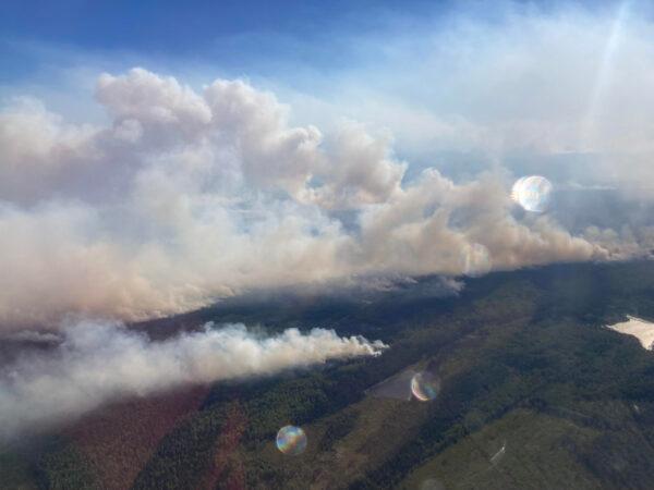
The Bearhole Lake Wildfire on Sept. 10, 2022. BCWS
According to the B.C. Wildfire Service (BCWS) the largest wildfire is burning in Battleship Mountain, 50 kilometres west of Hudson’s Hope.
“When a fire gets to the state that it has been over the last couple of days, this is no different than any natural disaster like a hurricane or tornado,” BCWS incident commander Scott Rennick said on Sept. 11.
“There is nothing we can do to get in front of it. We can’t put people in front of it, aircraft, heavy equipment. We just have to basically pull people back and make sure they’re safe.”
Discovered on Aug. 30 and suspected to be caused by lightning, the fire currently spans over 24,000 hectares. The district of Hudson’s Hope has declared a local state of emergency and an evacuation order is in effect.
Heather Lake
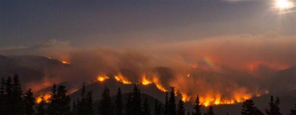
The northeast corner of the Heather Lake Wildfire on Sept. 7, 2022. BCWS
At Heather Lake in E.C. Manning Provincial Park, a wildfire that currently covers over 8,600 hectares was first discovered on Aug. 21. The fire crosses the American border, with around 3,700 hectares of it in Canada.
On Sept. 6, an evacuation alert was issued for the Community of Eastgate and parts of Manning Park. The fire is suspected to be naturally caused by lightning.
Bearhole Lake
First discovered on Aug. 31 and suspected to be caused by lightning, a fire spanning 6,300 hectares 8 kilometres east of Bearhole Lake continues to blaze.
A successfully planned ignition on Sept. 6 at the southeast corner of the fire secured that part of the perimeter before a shift in winds helped stop some of the spread, but the fire is still considered out of control and an evacuation alert is in effect. Planned ignitions are a commonly used wildfire-fighting tactic.
Highway 52 is closed between Boot Lake and Red Willow. An area restriction order in the Bearhole lake vicinity extends east of Highway 52.
Flood Falls Trail
First discovered on Sept. 8, an approximate 450-hectare wildfire southwest of Hope caused an evacuation alert for the District of Hope and the Fraser Valley Regional District, with evacuation orders for 12 properties.
The fire, suspected to be human-caused, is burning in steep areas, posing a challenge to firefighters on the ground. Efforts are being directed to protecting assets with a focus on the low elevations at the north flank near the Trans-Canada Highway. Visibility on the highway may be a concern; drivers are advised to be cautious.
Fry Creek
Also continuing to blaze is a 500-hectare wildfire 15 kilometres north of Kaslo on the east side of Kootenay Lake.
“The current heavy smoke from fires in BC, as well as Washington and Oregon, is diminishing fire behaviour on the Fry Creek wildfire. Moderate surface fire with a slow rate of spread is currently being experienced,” BCWS stated on Sept.11.
“Further growth is expected when the smoke clears,” it added.
Because of the smoke, aircrews can only fly in certain areas around the fire. Once the smoke starts to clear or shift, a more accurate estimate of the area covered by the fire will be available, the service said.
Recent History of BC Wildfires
According to BCWS, “the current 10-year average, taken from 2011 to 2020, is 1,352 wildfires from April 1 to March 31 the following year. On average, 42 percent of these are human-caused and 58 percent are lightning-caused.”
The worst year in B.C., going back to 2008, was 2017. On July 7 of that year, 108 fires were started by lightning, and 7,000 hectares were burned in a single day. A provincial State of Emergency was declared and lasted until Sept. 15 that year—the longest in B.C. history. Over 65,000 people were evacuated, and over 1.2 million hectares were burned.
Through mutual aid agreements, every other province in Canada, as well as Australia, New Zealand, Mexico, and the United States helped provide resources to fight the fires that year.