
This story was co-published with Source.
On October 13, we stepped off a boat in the middle of the Mississippi River Delta onto brand new land. The ground, about six months old, was a bit squishy but it held firm under our boots. It was put there by engineers working on a quixotic project to save Southeast Louisiana, which is sinking into the Gulf of Mexico at a rate of about a football-field every hour.
We had covered this area before, as part of our interactive story “Losing Ground.” We came here on a brisk but warm morning to bear witness and, especially, to take photos.
For our previous project, we were able to use freely available imagery from NASA’s Landsat 8 satellite to document the sinking of the delta. Those photos have a resolution of up to 15 meters to a pixel — ideal for big geographic areas like southeast Louisiana’s iconic “boot.”
But for our follow-up piece about the humongous patchwork of coastal restoration efforts including Louisiana’s Coastal Master Plan, we wanted to zoom into much smaller areas, highlighting a few of the projects that state, local and federal agencies have put in place to reverse some of the damage. Many of those projects would appear as tiny specks in Landsat’s sweeping view of the coastline. We needed a better aerial vantage point to show the progress of projects that in many cases were relatively small — some only a couple of thousand feet across.
Thankfully, the U.S. Geological Survey, through its EarthExplorer website, offers a vast cache of high-resolution digital images. These “orthoimages” are images taken from airplanes that have later been georeferenced — warped to fit onto a map — and stitched together into much larger images by the agency. In addition to true-color photographs, the orthoimages include an infrared band, which is required to work with the images, as it lets you easily and accurately isolate land and water — a key feature in delta regions where water can look like land because it is so heavy with sediment.
But the USGS does not fly orthophotography missions often. The most recent pass in the areas our stories covered was in 2012. With engineers building land as fast as they can, using backhoes and slurry pipelines, a lot can change in a year. What we needed were high-resolution aerial photographs of these areas right now. In remote sensing terms, what we needed was the holy grail: high temporal, spatial and spectral resolution. Like the old adage about fast, cheap and good, you don’t often get all three.
So we turned to a group called Public Lab, a nonprofit organization whose mission is to empower citizens to collect data about their environment with inexpensive or handmade tools. Public Lab has designed kits to collect aerial imagery with inexpensive point-and-shoot digital cameras hoisted on balloons and kites using rigs made with 3-D printers off of freely available plans. Scott Eustis, a coastal wetland specialist with the Gulf Restoration Network and volunteer organizer for Public Lab’s Gulf Coast chapter, offered to take us to two of the restoration sites we were focusing on for “Louisiana’s Moon Shot” in order to collect imagery with their DIY rigs.
The first project we mapped was a marsh creation project near Lake Hermitage, a village in Plaquemines Parish about 30 miles south of New Orleans that has dwindled to a seasonal fishing camp. In 2006, $37.9 million was approved to build 447 acres of land over 20 years here, in the form of two big sections of marsh near the eponymous lake under a 1990 law called the Coastal Wetlands Planning, Protection and Restoration Act. It’s a feat of engineering that sounds implausible. Huge pipelines from the nearby Mississippi would pump sediment into areas of water enclosed by man-made earthen berms. Then, like pizza dough, huge backhoes would push and smooth out the sediment until it filled the entire enclosed areas. Vegetation would be planted to anchor the land in place, preventing further erosion.
The creation of a third, 104-acre, $13 million section of marsh was approved under theNatural Resource Damage Assessment, a pool of Deepwater Horizon oil spill injury funds. That phase (barring some extra planting of vegetation) was completed in January.
As far as we knew, there were no aerial images of the completed project. We later found some, but more on that later.
So on a blustery morning in early October, with winds reaching 20-30 miles per hour, we set out from the fishing village on a 19-foot catamaran captained by Bob Marshall, a reporter with The Lens, and docked against what may have been the youngest land in the world.
In addition to sharing two Pulitzer Prizes and being one of the reporters on our “Losing Ground” project, Bob is also a lifelong resident of Southeast Louisiana. His 35 years reporting on its wetlands issues is informed by his lifetime of hunting and fishing experiences in the area’s marshes and swamps.
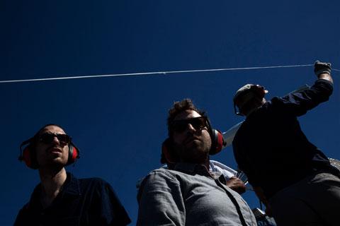
We did a few passes of the Hermitage marsh project with different camera rigs, with varying degrees of success. Public Lab uses both kites and balloons to collect images, but balloons – which can go much higher than kites – are nearly impossible to control in high winds, pitching backward and forward so much that they take useless photographs and are at an increased risk of crashing.
Luckily, GRN’s Eustis brought along a kite, which can handle strong winds. But that’s when we started running into trouble.
For our photos to be most useful for the project, we needed highspectral resolution, which for our purposes meant both visible and infrared light. Public Lab, when designing their kits, figured out that most cheap point-and-shoot cameras can be hacked to capture infrared light by removing physical filters blocking it. To create a multispectral image, Public Lab designed a rig that holds two cameras synced together: one capturing visible light, another hacked to capture infrared light. The images can later be combined in Photoshop to create a multispectral image.
Our need for infrared images ultimately sank the Lake Hermitage shoot. The kite, weighed down by the 25-ounce rig, was only to climb to an altitude of about 100 feet, producing images that were too close to the ground to be georeferenced, and not high enough to capture the full area we needed for our interactive project.
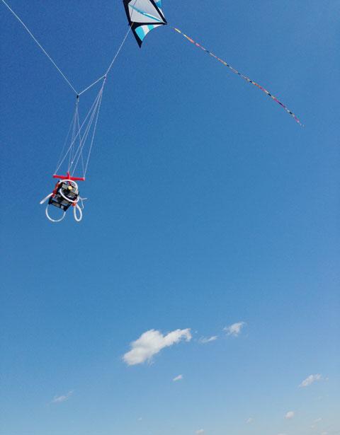
We did take a second kite pass of Hermitage using lighter rig — an ingenious device Public Lab calls the “Infragram” made up of a plastic soda-bottle top, a long kite tail and a tiny Mobius Action Cam, which was modified to only capture infrared light. The Infragram, weighing about an ounce, soared above the landscape. However, this flight, which we launched from Bob’s boat as he navigated the narrow channel between the two islands only captured a narrow band around the edges of the project.
Ultimately, to show the complete Hermitage project, we turned to Digital Globe, an outfit that sells very high resolution images. It turned out they had a recent enough photograph of the entire Lake Hermitage project, including infrared, taken on October 20.
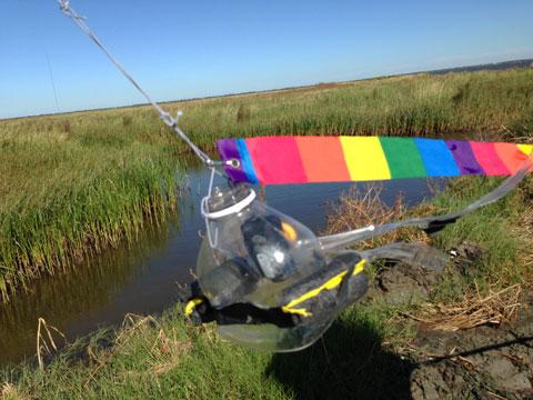
The next day, we set out to capture images of the West Bay Diversion, a 2003 project at the very end of the Mississippi River near what is called the Bird’s Foot Delta. The diversion is a strategic cut in the river levees designed to shunt sediment out into the bay where it is supposed to fall out of the stream and start building land. But for six years after it was built, the diversion didn’t work. Sediment moved too fast to build up where planners needed it to. New land started emerging after the Army Corps of Engineers solved the problem by building a series of small artificial islands in the bay starting in 2009.

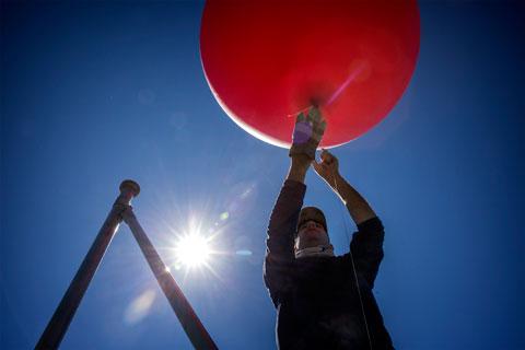
The winds were more favorable that day, so we were optimistic we would be able to launch the balloon rig — a six-foot-wide red weather balloon attached to 3,000 feet of string.
We arrived at the Cypress Cove marina, where Louisiana Highway 23 comes to an end after stretching down the length of the west bank of the Mississippi River. There we met Earl Armstrong, a cattle rancher from nearby Venice, La., who offered to take us in his airboat through the bayous to the diversion.
Armstrong is an advocate for the diversion. We profiled him in our “Losing Ground” project, and he was instrumental in the Army Corps’ decision to build the islands to slow down the sediment.
We climbed aboard, and donned earmuffs as his airboat roared to life. We weaved through the bayous around Venice, crossing Grand Pass, one of the wide streams that branches off from the end of the Mississippi to the gulf, until we approached the diversion. We could see enormous tanker ships gliding up the river beyond the levee.
We were extremely lucky to have Armstrong and his airboat as our guides; any other vessel would have run aground against the mud lumps and young Delta land studded with green.
We launched the balloon twice, unspooling about 2,000 feet of string as Armstrong piloted the airboat around a half-square mile triangle where sediment was accumulating near the diversion. It sure seemed to us like the state’s plan was working — the amount of new land and vegetation was striking.
The two cameras attached to the rig were synched to automatically take photos every five seconds. By the time we disembarked at Cypress Cove, we'd taken hundreds of images.
The hardest part of the project came when we got back to the office. Not only would we have to georeference a tiny triangle of some of the most unstable land in the world, we would have to match up the visible spectrum and infrared images in order to create our false color land/water classification maps.
We started by looking at both Google Earth images of the area of interest, and 2013 images from the National Agriculture Imagery Program, or NAIP (another high resolution true-color only dataset available from the USGS). Using these, we were able to match up the biggest, most persistent pieces of land. However, much had changed in the year since the NAIP image was taken. Using coordinates recorded on photos taken with iPhones while on the boat, we were able to track where the boat was when we launched the balloons. We were also able to use images of Bob’s boat, stashed nearby, as a ground control point. When we matched up a few images, near the boat marker, the others fell in like jigsaw pieces.


We used Photoshop’s warp-and-distort and scale transformations to stretch the images according to underlying features. We then added the infrared images and warped them to match the visible light images. With accurate alignment, we could then use the infrared data to create a land/water mask to accentuate the differences. Since we were building the entire image over the 2013 NAIP image, we were able to use the Geographic Imager plugin for Photoshop to convert our new mosaic into a GeoTIFF.

Getting high temporal, spatial and spectral resolution isn’t easy to do if you don’t have deep pockets. A single 10-square-mile multispectral georeferenced image from Digital Globe taken recently was expensive. We purchased two of these, including one for Bay Denesse, another area we wanted to feature in “Louisiana’s Moon Shot.” Public Lab’s DIY approach is admirable, and a promising work in progress — as are we as aerial photographers.
If we were to return, we might have alloted more time to return to Lake Hermitage on a less windy day, and we might have used slightly more expensive cameras, perhaps with embedded GPS units and gyroscopes to minimize processing time. That being said, the ability to control the entire mapping process from image acquisition all the way through to a final web map was priceless. So was our ability to witness for ourselves the delta being remade, and to meet the people with the biggest stake in the restoration’s success.
Many thanks to Scott Eustis and Jordan Macha from the Gulf Restoration Network, Shannon Dosemagen, Stevie Lewis and Stewart Long from Public Lab for arranging the trip, providing the tools, training and cartography consulting, Knight-Mozilla OpenNews for helping pay some of The Lens’ and Public Lab’s costs, Earl Armstrong and Bob Marshall for indulging us as armchair orthophotographers, if only for a week.
Republished with permission from ProPublica. Read the original.
