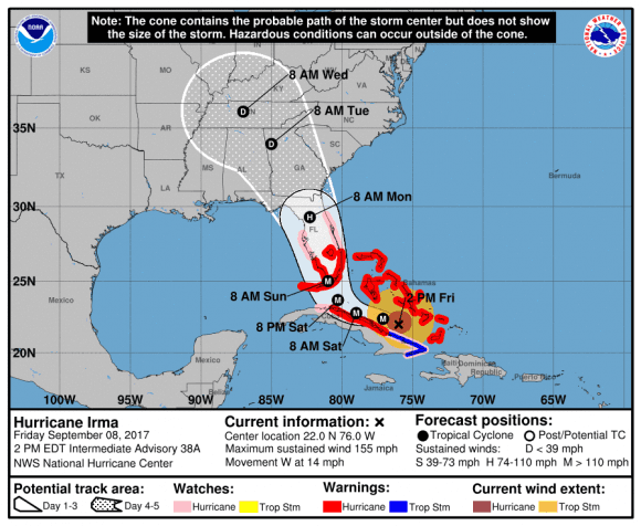
Southwest Florida will likely face flooding from Hurricane Irma storm surge with waters rising up to 12 feet above ground level, according to the U.S. National Hurricane Center (NHC).
The southwestern coast of Florida from Captiva to Cape Sable will be hit hardest, the NHC said in a 2 p.m. advisory released on Friday, with the water rising 6-12 feet above the ground.
The area from Jupiter Inlet to Cape Sable, including the Florida Keys will see waters rise 5-10 feet. Meanwhile, the stretch of coast from Ponce Inlet to Jupiter Inlet and from Venice to Captiva will see storm surges of 3 feet to 6 feet, the NHC said.

The worst flooding is likely to occur if the peak surge from the storm occurrs during the high tide.
"The deepest water will occur along the immediate coast in areas of onshore winds, where the surge will be accompanied by large and destructive waves," the NHC said in the advisory.
The amount of flooding depends on a number of factors and the NHC is advising residents to check with the local the National Weather Service for a more precise forecast.

Hurricane Irma was moving west at 14 mph as of the 2 p.m. advisory with maximum sustained winds blowing at 155 mph. The storm is expected to remain a powerful Category 4 hurricane as it approaches Florida.
In addition to the flooding from the storm surge, Irma will dump up to 20 inches of rain in Florida, Georgia, South Carolina, and western North Carolina. Upper Florida Keys will see the most precipitation with 10 to 15 inches of rain, according to the NHC. Isolated areas in the Upper Keys will get up to 20 inches of downpour.
"In all areas this rainfall may cause life-threatening flash floods and, in some areas, mudslides," the NHC said.

Showers and thunderstorms associated with Hurricane Irma will begin in Florida on Friday evening and continue Saturday night and into Sunday, according to the National Weather Service.
From NTD.tv