9 Earthquakes Hit California in Less Than 24 Hours Over Christmas Holiday

California was hit by nine earthquakes in less than 24 hours on Christmas Eve and before dawn on Christmas morning.
9 Earthquakes Hit California in Less Than 24 Hours Over Christmas Holiday
Nine earthquakes hit California on Christmas. (USGS)
Katabella Roberts
12/26/2019
Updated:
12/26/2019
California was hit by nine earthquakes in less than 24 hours on Christmas Eve and before dawn on Christmas morning, The Sacramento Bee reported.

The earthquakes reached up to 3.2 magnitude and shook the state from Los Angeles to the northern city of Chico.

Other quakes ranged from 2.5 to 3.9 magnitude and stretched the length of the state, according to the U.S. Geological Survey (USGS).

The biggest quake hit near the town of Idyllwild, in the San Jacinto mountains east of Los Angeles, at 8:24 p.m. on Christmas Eve. USGS said that it was 9.6 miles deep and was felt as far away as Rancho Cucamonga city and Redondo Beach.

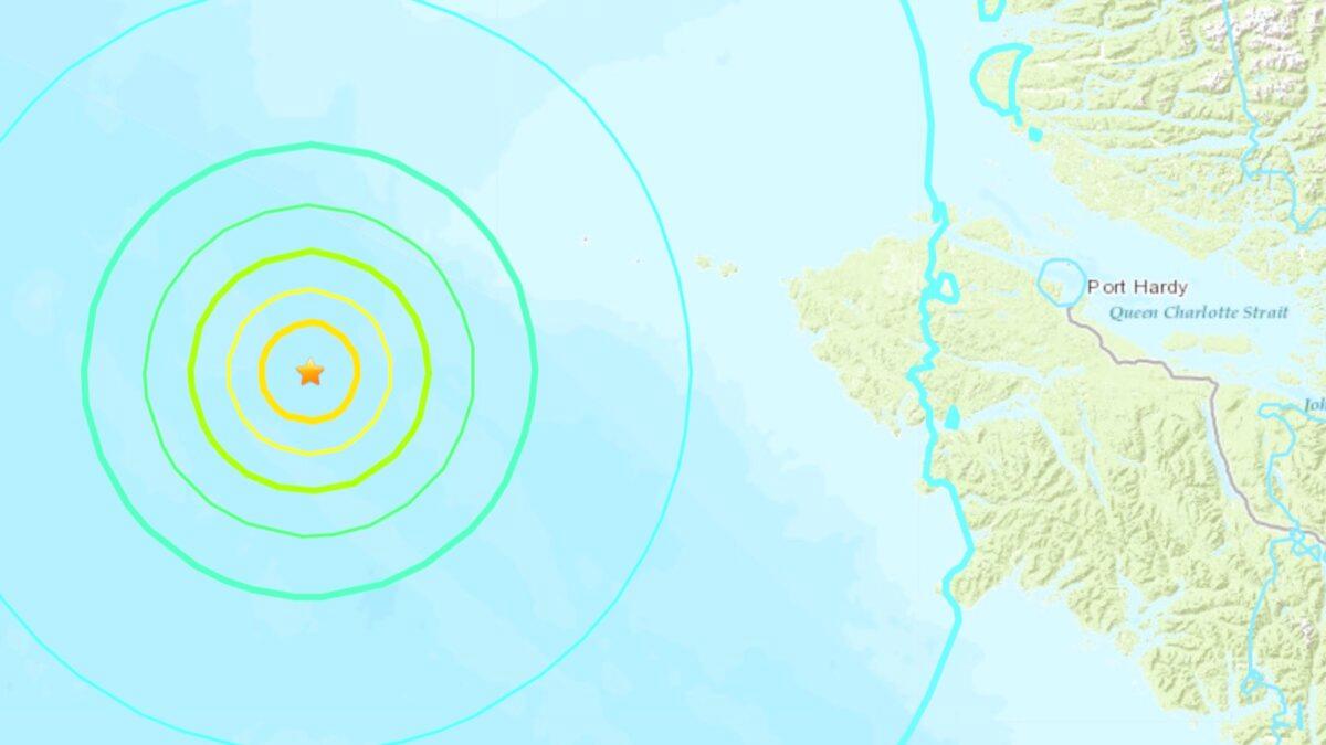
An substantial 6.3 magnitude quake struck a spot off the coast of British Columbia on Christmas eve, around 182 kilometers (113 miles) west of Port Hardy, a town of about 4,100 people.

It had a depth of 6.2 miles and people reported feeling it in more than 300 miles away in Vancouver, USGS said.

A 6.3 magnitude quake struck a spot off the coast of British Columbia on Christmas eve, around 113 miles west of Port Hardy, Canada. (USGS)
According to The National Earthquake Information Center (NEIC), California generally gets two or three earthquakes with a magnitude of 5.5 and higher every year.

These earthquakes are considered large enough to cause moderate damage to buildings and infrastructure in the state.

Earlier this year in July, California was hit by its most powerful earthquake in nearly 20 years when a huge 7.1 magnitude quake struck.

The strongest earthquake to hit the state on record measured 7.9 in magnitude and hit near Fort Tejon in 1857, leaving a surface rupture scar over 217 miles in length along the San Andreas fault.
In October, California governor Gavin Newsom announced the launch of the first state-wide earthquake early warning system, which uses reports from sensors embedded in the ground to detect tremors.
California Gov. Gavin Newsom during an interview in his office at the Capitol in Sacramento, Calif., on Oct. 8, 2019. (Rich Pedroncelli/AP Photo)

A warning is then delivered to mobile phones using the Wireless Emergency Alert system, which delivers critical warnings and information to the public on their wireless devices, or via the MyShake app, which was developed by the University of Berkeley Seismology Lab.

The system was launched on the 30th anniversary of the devastating Loma Prieta earthquake that killed 63 people in the San Francisco Bay Area.

Developers say the MyShake app provides “tens of seconds” of warning to people before they might feel the ground shaking, allowing them enough time to drop, cover, and hold on to help prevent injury.

However, the amount of notice people receive will depend on how far away they are from the epicenter of the earthquake.