Heavy rain is set to continue across Australia’s far north and southeast, bringing potentially life-threatening floods.
Multiple flood warnings have been issued across New South Wales (NSW), the Northern Territory’s northwest, Victoria and southern Queensland.
Sydney’s outer west was part of a severe thunderstorm alert issued on Wednesday afternoon covering a swathe of northern and central NSW, including Katoomba, Orange and Dubbo.
Eyes were also on towns in and west of the Australian Alpine region, where storms and heavy rain were possible but intense deluges no longer likely.
Six-hourly rain totals of 50-80mm were likely, with motorists between Melbourne and Sydney possibly affected.
“The main risk associated with this storm is localised heavy rainfall leading to flash flooding and damaging winds,” the State Emergency Service said.
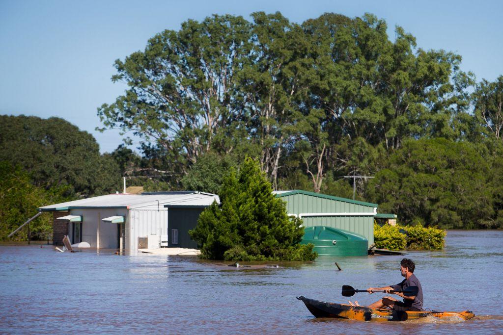

Flooding has eased elsewhere in NSW including for 500 residents of Darkwood, near Coffs Harbour, cut off by a swollen Bellinger River until about midday on Jan. 17.
Some rural properties on the Orana River, near Grafton, remain isolated but that river is also receding.
In the Top End, a severe weather warning was issued on Wednesday morning for Daly, Tiwi, Arnhem, Gregory and parts of Carpentaria, Barkly and Tanami districts.
Locations possibly affected included Darwin, Katherine, Nhulunbuy, Palmerston, Jabiru, Maningrida, Wadeye, Wurrumiyanga and Nauiyu.
In Western Australia, warnings were issued for severe thunderstorms in the Kimberley region while 22,000 people in the Perth Hills and wheatbelt remain without power after storms tore down hundreds of poles and wires on Jan. 16.
“The damage area is massive, with seven transmission lines out of service,” Western Power acting chief executive Jacqui Hall said.
“All available crews, including regional, have been deployed and we have called contractors in and mobilised helicopter patrols. All planned works have been cancelled where not critical.”
WA Police warned some in wheatbelt areas could not access triple zero or the police assistance line.
The bureau has also warned there is a significant risk of a cyclone again impacting far north Queensland next week.
The region is already recovering from record flooding caused by Cyclone Jasper just weeks ago.
It is bracing for another cyclone after a tropical low developed off Cairns.
The low is set to stay offshore this week, developing into a cyclone by Jan. 22 and is a chance of tracking back toward the Queensland coast.
“There is a significant risk that this system will impact the Queensland coast during next week - a severe impact is possible,” the bureau’s website said.
Coastal areas between Cooktown to Mackay may be impacted by late Jan. 23.
Cyclone Anggrek has already formed in the Indian Ocean and is set to become a category 2 system in coming days, entering Australian waters this week.
“It is highly unlikely to have any impact on mainland Australia but gale force winds could be felt in the Cocos Islands,” the bureau said.