Floods, fires and cyclones have taken enormous social, economic and environmental tolls on Australia. The State of Weather and Climate Extremes 2023 report looks at 11 major incidents.
1. Ex-cyclone floods the Kimberley:
For a fortnight into early 2023, ex-tropical Cyclone Ellie slowly moved across the Northern Territory and the Kimberley in Western Australia.
Rivers hit record heights and the Fitzroy beat the previous record by almost two metres. Dimond Gorge had 838.8mm of rain in 10 days, just shy of its annual average rainfall.
Damage was put at $322 million. Critical infrastructure was damaged, people were evacuated, communities were cut off and food was in short supply.
The report doesn’t attribute the cyclone to climate change but does not rule out warming as a factor. It says climate change could mean fewer cyclones for Australia, but a higher proportion of intense ones like Ellie.
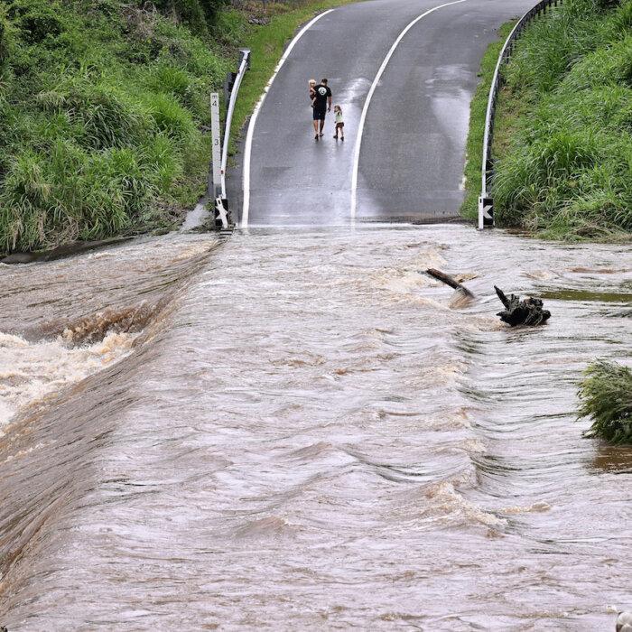

2. Floods in the NT and Queensland:
In late February and early March, a persistent low-pressure system flooded remote communities in the Northern Territory and Queensland’s northwest.
It was long-lived and slow-moving, leading to incredible rainfall totals over several days.
Flooding in remote locations stretched emergency services, and three Indigenous communities were relocated to Darwin where people remained stuck for up to three months.
Transport routes were disrupted and there were food shortages.
3. Winter heat in NSW:
NSW and the city of Sydney notched up their warmest winters since records began.
In July, the temperature was about 3.5C higher than the long-term average.
Persistent high-pressure systems held off easterly winds that can bring rain. Unusual westerly and northwesterly winds also delivered warm, dry air.
It warns winters in southeast Australia will continue to warm and cool-season heat events will become more frequent and intense under climate change.
4. Snow season dies early:
After a strong start, Australia’s snow season met an early end with the nation’s warmest winter on record fuelling rapid snow loss in the Alps.
September was extremely dry, and the hottest September on record in the Alps, and that delivered a savage blow for local economies that depend on the snow.
Poor snow seasons can’t yet be attributed to climate change but that doesn’t mean it wasn’t involved, the report says.
Snow depths have been steadily declining in past decades, while alpine temperatures rise.
5. South Australia’s September heatwave:
A record heatwave with extreme temperatures 10C to 20C above average hit large parts of South Australia in mid-September.
Unseasonably high temperatures are part of a larger trend in southeast Australia, where heatwaves are becoming more frequent, more intense, and occurring earlier than usual due to climate change, the report says.
It warns of serious implications for human health, agriculture, and the environment.
6. Gippsland sees fires and floods in the space of a week:
Early spring bushfires hit Victoria’s Gippsland region in October. When a low pressure system arrived it put out the fires, but caused widespread flooding.
About 130 properties were flooded and the SES fielded hundreds of calls for help.
7. Bushfires hit early in Queensland:
More than 1000 bushfires broke out in Queensland at the end of October, marking an early start to the season.
The Western Downs region in the state’s southeast was hit hard, with more than 20,000 hectares burnt near the town of Tara.
Not only were the fires early, they were more persistent and continued to burn at night thanks to exceptionally hot and dry conditions, which the report notes will be more likely with climate change.
The fires also coincided with the return of El Nino and the driest September since 1900, which rapidly dried out vegetation growth during three preceding years of wetter La Nina conditions.
8. Rain-wind event lashes Hobart:
Tasmania was hit by a slow-moving low-pressure system in October, dumping a month’s worth of rain over large parts of the state.
Another low packing extreme winds hit two days later, uprooting trees from rain loosened soil and wreaking havoc in the south, including Hobart.
A third system then delivered winds of 98km/h in Hobart, and 159km/h on Mt Wellington. The winds did much more damage than usual due to the soil being saturated.
More than 7000 properties lost power state wide, and properties, cars and other infrastructure were destroyed by falling trees.
The damage would have been far less if the events had not been back to back, the report says.
Researchers have found extreme winds-and-rain compound events will happen more frequently in many regions without effective action on climate change.
9. Hail storm batters Queensland’s food bowl:
A supercell thunderstorm brought heavy hail and extreme wind to Queensland’s Lockyer Valley in November.
One person died and damage to crops and farm equipment was estimated at $50 million.
The report notes severe thunderstorms are expected to be affected by climate change but it’s difficult to say exactly how.
A broad expectation is there'll be fewer hailstorms overall, but larger hailstones when they develop.
Research continues into climate-related changes to severe thunderstorms and their associated hazards.
10. Cyclone Jasper hits far north Queensland:
Category two Cyclone Jasper struck north of Cairns in mid-December, delivering torrential rain and flooding.
After crossing the coast it stalled over Cape York, contributing to a week-long deluge that inflicted major damage.
A large part of the far north recorded more than 400mm of rain. Some places copped over two metres.
The system caused major damage to roads, the power network, buildings, crops and closed the Cairns airport just before Christmas.
Research continues into the stalling of the system, something that also happened in February 2019, causing flooding in Townsville.
11. Antarctic sea ice hits record low:
The extent of sea ice that surrounds Antarctica changes constantly. It grows during cooler months from March to September, before rapidly shrinking from October to February.
Scientists say climate change is having major impacts and in 2023, sea ice extent hit record lows in both winter and summer.
Sea ice still grew in the cooler months but much slower than in previous years.
The shift, from 2016 onwards, is consistent with climate change projections and aligns with warmer ocean temperatures.
The report warns a very low sea ice extent is unmatched in historical observations and has implications for the global climate system, including sea level rise.