Tropical Storm Fred is expected to make landfall in eastern Florida on Monday before moving to Georgia on Tuesday.
The storm, which has winds of up to nearly 60 mph, with higher gusts, is moving north close to 10 miles per hour, forecasters with the National Hurricane Center say.
Landfall is expected in the eastern Florida Panhandle between Pensacola and Tallahassee on Monday afternoon or early evening.
The storm may strengthen just before touching land but forecasters believe it will “quickly weaken” after landfall, according to a public advisory from the center, which is located in Miami.
Still, people are advised that the storm will likely bring a dangerous storm surge and heavy rains.
A storm surge warning is in effect for the coast of Florida from Indian Pass to Yankeetown, with a tropical storm warning for the coast of the Florida Panhandle and Big Bend from Navarre to the Steinhatchee River.
The former means forecasters are projecting the possibility of life-threatening inundation from rising water moving inland. The latter means tropical storm conditions are expected, in this case within the next 12 hours.
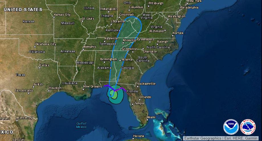
Through Monday, some areas of southern and central Florida are expected to get 1 to 2 inches of additional rain, with isolated parts receiving 5 inches. The Florida Big Bend and Panhandle are expected to get 4 to 8 inches of rain with isolated areas getting 12 inches through Tuesday.
Southeast Alabama through western and northern Georgia, and the western Carolinas, are also expected to get between 4 and 10 inches of rain through Tuesday.
Portions of other nearby states could see up to 4 inches of rain through Wednesday as the storm continues moving.
Heavy rainfall in the states could lead to some flooding. The rain could trigger landslides across the mountains of North Carolina.
Officials in northern Florida are sending alerts to residents to monitor the situation.
“Forecasts call for a strong tropical storm at landfall. Conditions will deteriorate throughout the day. Please stay off the roads if possible as there is potential for flash flooding and road closures,” the Bay County Emergency Services said Monday.
Kevin Guthrie, director of the Florida Division of Emergency Management, encouraged people in the Panhandle to turn on weather alerts, monitor local news outlets, and follow the division on social media to stay informed.