Tropical Storm Dorian Expected to Be Hurricane by Labor Day

Tropical Storm Dorian Expected to Be Hurricane by Labor Day
Coastal Watches/Warnings and Forecast Cone for the storm center. (National Hurricane Center)
Tom Ozimek
8/28/2019
Updated:
8/28/2019

The U.S. National Hurricane Center said Tropical Storm Dorian is expected to strengthen into a Category 2 hurricane before making landfall in Florida on Labor Day.

The storm is forecast to strengthen into a Category 1 hurricane by Friday morning and is expected to continue to strengthen to a Category 2 storm by Sunday morning before it makes landfall along the east coast of Florida or Georgia Monday morning, according to the Coastal Watches/Warnings and Forecast Cone for Storm Center issued by the NHC.
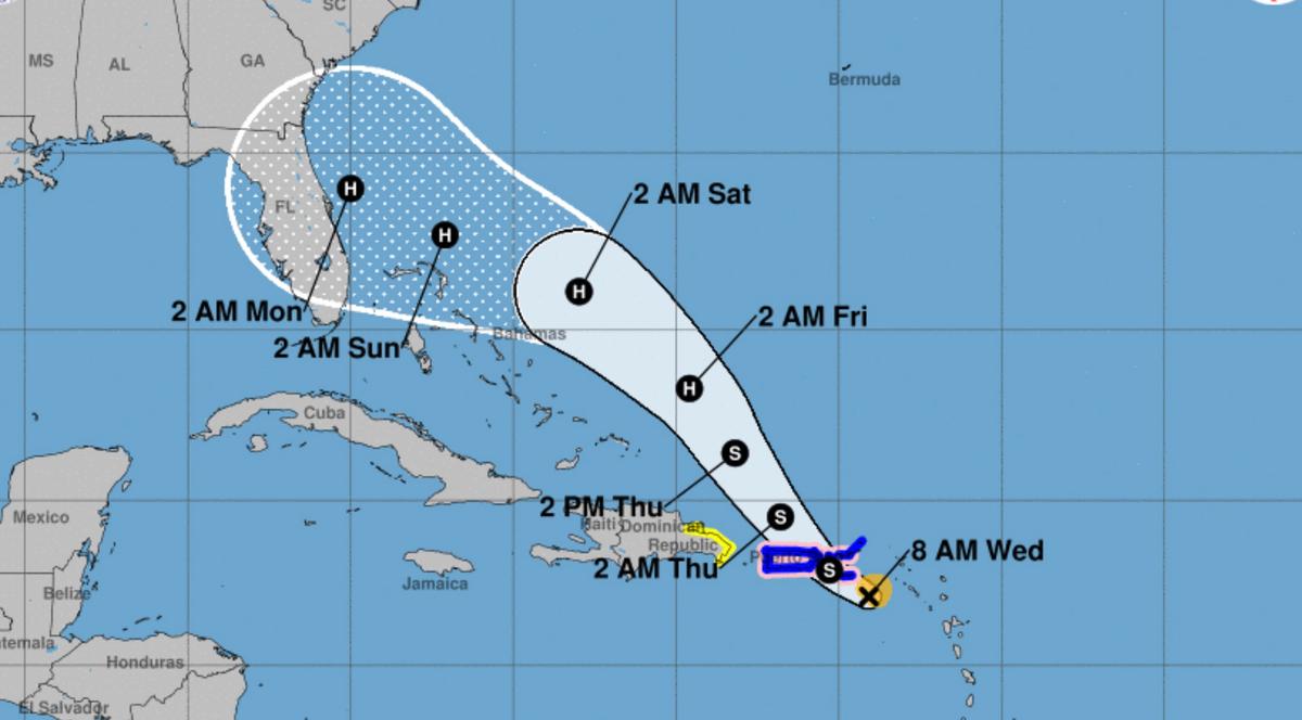
Coastal Watches/Warnings and Forecast Cone for Storm Center. (National Hurricane Center)
Florida Gov. Ron DeSantis was cited by CNN as saying on Tuesday, Aug. 27, that he was briefed by the Florida Division of Emergency Management Director Jared Moskowitz on the need to start preparing for Dorian’s possible landfall.

“Based on the current track of Tropical Storm Dorian, all residents on the east coast should prepare for impacts, including strong winds, heavy rain, and flooding,” DeSantis said, according to the report. “Make sure to have your supplies ready and follow @FLSERT [Florida Division of Emergency Management] and local media for the latest updates on the forecast.”

“There is a chance for rapid intensification just before making landfall somewhere along our east coast,” News 6 meteorologist Troy Bridges said.
“We will see the impacts in Central Florida, including some rain from Dorian, well before landfall, possibly by late Friday or early Saturday,” Bridges said. “It is still too early to tell specifics about our impacts, however.”

Tropical Storm Dorian Advisory

According to the most recent Public Advisory on Tropical Storm Dorian, published by the NHC at 5 a.m. ET on Aug. 28, the storm’s center was approximately 85 miles southeast of St. Croix and moving northwest at 13 miles per hour, with maximum sustained winds of 60 miles per hour.
Dorian is expected to produce hurricane conditions in the Virgin Islands and Puerto Rico later in the day, the NHC said.

The following Hurricane Watch and Tropical Storm Warning notices are in effect:

A Hurricane Watch is in effect for:

Puerto Rico Vieques Culebra U.S. Virgin Islands

A Hurricane Watch means that hurricane conditions are possible within the watch area within 24 hours.

A Tropical Storm Warning is in effect for:

Puerto Rico Vieques Culebra U.S. Virgin Islands British Virgin Islands Dominican Republic from Isla Saona to Samana

A Tropical Storm Warning means that tropical storm conditions are expected somewhere within the warning area within 24 hours.

Hurricane Center Key Messages

The Hurricane Center issued a set of key messages for Tropical Storm Dorian.

The first key message in their 5 a.m. Advisory #16 was the expectation of tropical storm conditions for the U.S. and British Virgin Islands and Puerto Rico today, and the possibility of tropical storm conditions in parts of the Dominican Republic tonight and Thursday. Puerto Rico and the Virgin Islands can expect the possibility of hurricane conditions today.

The second key message is that heavy rainfall is expected over parts of Puerto Rico and the Virgin Islands, which “could produce flash flooding during the next couple of days.” Florida and the Bahamas can expect heavy rainfall later this week and into early next week.

The third key message is that of an increased threat of tropical storm or hurricane conditions or surge in the northwestern Bahamas and parts of Florida. Affected residents are advised to have a hurricane plan.

The final message is that of increased uncertainty in the intensity forecast for the latter part of the week due to issues with the predicting model.

Tropical Storm-Force Winds

The hurricane center said that maximum sustained winds are near 60 mph with higher gusts. Tropical storm-force winds extend outward up to 60 miles from the center, the center noted.

“Some strengthening is expected today, and Dorian is forecast to be near hurricane strength when it approaches the Virgin Islands and Puerto Rico. Although weakening is possible after Dorian moves across Puerto Rico and the Virgin Islands, the storm is forecast to strengthen late this week and this weekend while passing near or to the east of the Turks and Caicos and the Bahamas,” the NHC notes.

Tropical Storm-Force Wind Speed Probabilities graphic. (National Hurricane Center)

“Swells generated by Dorian are gradually subsiding in the Lesser Antilles. Swells are expected to increase later this morning across the U.S. and the British Virgin Islands and along the southern coasts of Puerto Rico and Hispaniola, and they could cause life-threatening surf and rip current conditions.”

The hurricane center adds people should additionally consult products from local weather offices.

Dorian is the fourth tropical storm in the Atlantic this year and is poised to become the first hurricane this season.

Trump Approves Puerto Rico Emergency Declaration

On Tuesday, the White House announced that President Donald Trump has declared a state of emergency in Puerto Rico due to Tropical Storm Dorian and ordered Federal assistance to supplement commonwealth and local response efforts due to the emergency conditions.

“The President’s action authorizes the Department of Homeland Security, Federal Emergency Management Agency (FEMA), to coordinate all disaster relief efforts which have the purpose of alleviating the hardship and suffering caused by the emergency,” the announcement reads.

Trump wrote in a tweet that “FEMA and all others are ready, and will do a great job.”

The aim of the Federal assistance, which covers actions in all 78 municipalities in Puerto Rico, is “to save lives and to protect property and public health and safety, and to lessen or avert the threat of a catastrophe.”