‘Dramatic’ Warmup Expected Soon Across Most of US: Forecasters

A large portion of the United States will see significantly higher temperatures soon
‘Dramatic’ Warmup Expected Soon Across Most of US: Forecasters
A map issued on Jan. 16, 2024, shows the forecasted temperatures across the lower 48 states. (NOAA Climate Prediction Center)
Jack Phillips
1/17/2024
Updated:
1/17/2024
0:00

A large portion of the United States will see significantly higher temperatures starting in a few days, according to the U.S. National Weather Service and other forecasters.

The weather service’s 6-to-10-day outlook, issued Jan. 16, shows that the entire continental United States, Hawaii, and some portions of Alaska will see slightly higher to well-above-normal temperatures between Jan. 22 and Jan. 26.
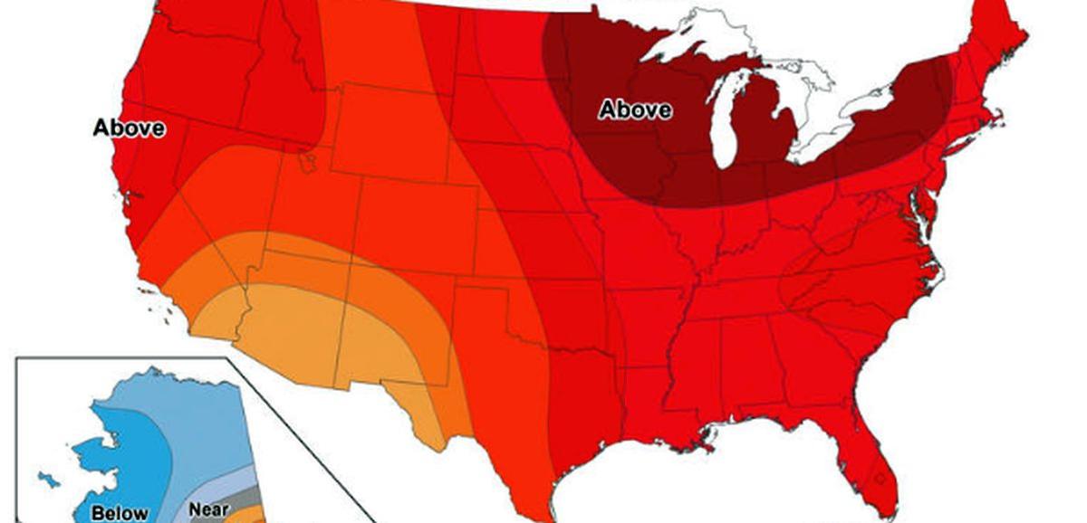
“A dramatic warmup is expected across the Lower 48 starting next week and lasting at least the next 10 days,” Richard Tinker, a meteorologist at the Climate Prediction Center, told USA Today. “One more shot of cold air is expected later this week.

“After that, the ‘deep freeze’ will ease its grip, and odds favor above-normal temperatures for the following 10 days or so across the entire Lower 48.”

AccuWeather long-range meteorologist Paul Pastelok told the newspaper that about 90 percent of the United States will see normal to above-normal temperatures starting in the middle of next week. He said that the temperature differential will be 8 to 14 degrees F higher than usual for the Midwest and Plains states, which have been hard-hit by below-zero temperatures this week—some of which hit record lows.

“It will be a huge difference for folks in the Plains and Midwest,” Mr. Pastelok said.

According to the Farmer’s Almanac, “In areas where winter weather is exceptionally cold, temperatures during the thaw may not even rise above freezing,” referring to the so-called “January thaw” that sometimes occurs in the final week of the month. Some areas, however, could see a “false spring,” it notes.

More Inclement Weather

The forecast came as much of the United States copes with bitter weather that, in some places, put electricity supplies at risk. Another day of bitter temperatures swept much of the Rockies, Great Plains, and Midwest, with wind chills below minus 30 extending into the mid-Mississippi Valley.

Freezing temperatures spread as far south as North Florida on Jan. 17, said Bob Oravec, a forecaster at the National Weather Service, The Associated Press reported. It was 12 degrees early on Jan. 17 in Atlanta, where thousands of students were just returning to school after several of Georgia’s largest school systems closed a day earlier as icy weather threatened the region.

It was 5 degrees in Chicago and 6 degrees in Detroit, making both cities significantly colder than Alaska’s capital of Juneau, where it was 18 degrees. Some residents managed to find a bright side.

Residents of the Pacific Northwest suffered more misery as an ice storm bore down on Jan. 17, threatening to topple towering trees, turn mountain highways treacherous, and zap power in bitterly cold temperatures. Much of the region was under an ice storm warning through the morning, promising only to add to the damage brought by a powerful winter storm that hit over the weekend.

Parts of southwest Washington and western Oregon, including the latter state’s largest cities of Portland, Salem, and Eugene, expected a quarter-inch to an inch of ice while freezing rain was forecast in the Seattle area.

Schools were closed, bus service was curtailed, and warming shelters opened while officials warned of bad roads and the chance of new power outages, even as crews struggled to restore electricity to thousands of customers who were blacked out for days.

That storm currently affecting the Pacific Northwest will move across the United States, delivering snow from Chicago to Washington, and later in New York City and Boston, forecasters say. That storm has the potential to bring several inches of snow to some areas, according to AccuWeather.

After that, “temperatures are likely to rebound substantially over the Midwest and East,” the forecasting firm said.

Then, “a storm track toward the Great Lakes is likely to resume, which would tend to push most areas onto the warmer side of the storms, at least for most of the time. There will likely still be some episodes of snow and ice on the front end of the storms over the northern tier.”

The Associated Press contributed to this report.
Jack Phillips is a breaking news reporter with 15 years experience who started as a local New York City reporter. Having joined The Epoch Times' news team in 2009, Jack was born and raised near Modesto in California's Central Valley. Follow him on X: https://twitter.com/jackphillips5
twitter
Related Topics