UFO in Peru Nearly Strikes Plane (Video)

UFOs: Yet another UFO encounter has been recorded for 2011, this time in Peru in footage taken from a light aircraft on New Year’s Day. And it might have been navigating the Nazca lines.
UFO in Peru Nearly Strikes Plane (Video)
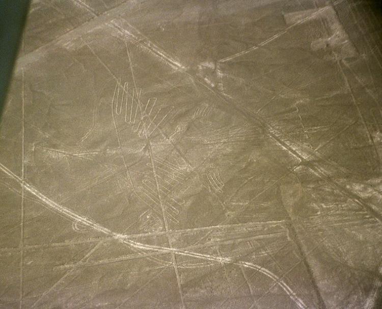
The Nazca Lines are geoglyphs (drawings on the ground) located in the Nazca Desert, a high arid plateau that stretches 53 miles between the towns of Nazca and Palpa on the Pampas de Jumana (a large flat area of southern Peru). In this picture, is the figure known as the condor. (Courtesy of Wikimedia Commons)
2/11/2011
Updated:
10/1/2015

[video]www.youtube.com/watch?v=hjfsuBY48c0&annotation_id=annotation_607071[/video]

Video Filmed From Plane Over the Nazca Lines

Yet another UFO encounter has been recorded for 2011, this time in Peru in footage taken from a light aircraft on New Year’s Day.

According to the video on YouTube, two medical professionals took an early morning flight in a Cesna plane to observe the Nazca Lines in Peru, near the foothills of the Andes.

In the YouTube video, at around 3'28, the aircraft is flying through rain clouds, when suddenly a UFO appears in a hole in the clouds, about 20 to 30 feet from the plane and seemingly on a collision course.

The grey disk rapidly changes course and disappears back into the clouds, all within the space of a couple of seconds. Subsequent slow footage and still frame analysis of the incident clearly shows a flying saucer-shaped object.

Is it possible the UFO was an alien craft navigating above the mysterious Nazca Lines?

These geoglyphs have puzzled modern man since they were discovered in the 1920’s. They are not visible from the ground, but are highly visible from the air, criss-crossing the world’s driest desert, where they persist due to the lack of rain and wind.

They may have been created by the Nazcas, who lived from 200 BC to 700 AD, but their function is unclear. For many years, it has been theorized that they are associated with UFOs, because they are only visible from high altitudes.

<a><img class="size-medium wp-image-1808480" title="The Nazca Lines are geoglyphs (drawings on the ground) located in the Nazca Desert, a high arid plateau that stretches 53 miles between the towns of Nazca and Palpa on the Pampas de Jumana (a large flat area of southern Peru). In this picture, is the figure known as the condor. (Courtesy of Wikimedia Commons)" src="https://www.theepochtimes.com/assets/uploads/2015/09/741px-Nazca-lineas-condor-c01.jpg" alt="The Nazca Lines are geoglyphs (drawings on the ground) located in the Nazca Desert, a high arid plateau that stretches 53 miles between the towns of Nazca and Palpa on the Pampas de Jumana (a large flat area of southern Peru). In this picture, is the figure known as the condor. (Courtesy of Wikimedia Commons)" width="320"/></a>
The Nazca Lines are geoglyphs (drawings on the ground) located in the Nazca Desert, a high arid plateau that stretches 53 miles between the towns of Nazca and Palpa on the Pampas de Jumana (a large flat area of southern Peru). In this picture, is the figure known as the condor. (Courtesy of Wikimedia Commons)

In 1941, history professor Paul Kosok watched sunset directly above one of the lines, and hypothesized that they could mark the positions of the sun and other stars at different times of the year, describing the lines as “the largest astronomy book in the world,” according to National Geographic.

But the idea has since been refuted by astronomers, who showed that there are no meaningful associations between the lines and celestial objects.

Nevertheless, the theory was popularized by Erich von Däniken, who wrote Chariots of the Gods?, proposing that the lines are “an airfield ... built according to instructions from an aircraft.” Some of the lines could also be signals to these extraterrestrials, who may have visited Peru during the time of the Nazca people, subsequently leading to them worshipping these “gods,” National Geographic reported.

Another hypothesis, the subterranean water theory, suggests the lines signify geological faults where water flows underground, which would have been vital to people dwelling in the desert.

Some shapes like trapezoids mark fault lines directly, while others point to these lines, and yet others mark aquifer boundaries or points where the direction of water flow changes. If correct, the lines are actually “a complex map of underground water resources,” National Geographic suggests.