Tropical Storm Fernand Forms in Gulf of Mexico, Other Disturbances Being Monitored

Tropical Storm Fernand Forms in Gulf of Mexico, Other Disturbances Being Monitored
Fernand has 40 mph maximum sustained winds, and is located 160 miles east of La Pesca, Mexico, on Mexico's east coast. (NHC)
Jack Phillips
9/3/2019
Updated:
9/3/2019

Tropical Storm Fernand has formed in the Gulf of Mexico as Hurricane Dorian continues to lash the Bahamas, highlighting the notion that early September seems to be the peak for the Atlantic hurricane season.

The U.S. National Hurricane Center (NHC) said in a 1 p.m. advisory that Fernand has 40 mph maximum sustained winds, and is located 160 miles east of La Pesca, Mexico, on the country’s east coast.
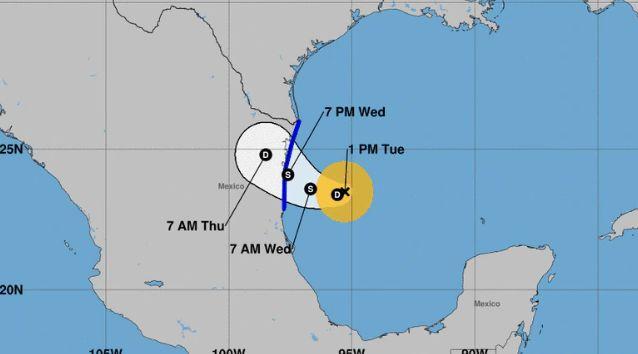
The storm is moving west at 7 mph.

The NHC is monitoring several tropical disturbances in the Atlantic basin (NHC)

“The Government of Mexico has issued a Tropical Storm Warning for the northeast coast of Mexico from La Pesca to Barra del Tordo and from Barra El Mezquital to the Mouth of the Rio Grande River,” the agency said, adding that the center of Fernand’s center could be near or over the coast of northeastern Mexico by late Wednesday.

It’s expected to drop 6 to 12 inches of rain with isolated areas getting 15 inches of rain. The NHC said this could cause mudslides and flash flooding.

Meanwhile, there is a tropical disturbance several hundred miles west of the Cabo Verde Islands. There is a 90 percent chance of a tropical depression forming over the next 48 hours.

Several hundred miles south of Bermuda, meanwhile, “showers and thunderstorms associated with a trough of low pressure, located several hundred miles south of Bermuda were showing some signs of organization,” the agency said. “Development of this disturbance is possible during the next couple of days while it moves northward. Interests in Bermuda should monitor the progress of this system. Periods of heavy rainfall are likely to impact Bermuda.”

And a tropical wave is forecast to develop between Africa and the Cabo Verde Islands. Over five days, the formation of a tropical depression is 70 percent favorable.

Strong winds move the palms of the palm trees upon Hurricane Dorian’s arrival in Freeport, Grand Bahama, Bahamas, on Sept. 1, 2019. (Ramon Espinosa/AP Photo)
The National Oceanic and Atmospheric Administration said Sept. 10 is the most likely date a tropical storm or hurricane will be churning in the Atlantic or Gulf of Mexico.

The peak of the season is usually from mid-August until late October.

“Hurricanes start simply with the evaporation of warm seawater, which pumps water into the lower atmosphere,” the NOAA explains. “This humid air is then dragged aloft when converging winds collide and turn upwards. At higher altitudes, water vapor starts to condense into clouds and rain, releasing heat that warms the surrounding air, causing it to rise as well. As the air far above the sea rushes upward, even more warm moist air spirals in from along the surface to replace it.”
Jack Phillips is a breaking news reporter with 15 years experience who started as a local New York City reporter. Having joined The Epoch Times' news team in 2009, Jack was born and raised near Modesto in California's Central Valley. Follow him on X: https://twitter.com/jackphillips5
twitter
Related Topics