Tornado Watch Issued for New York

A week and a half after two tornadoes struck New York City, the National Weather Service issued a tornado watch on Tuesday.
Tornado Watch Issued for New York
A supplemental weather graphic of the Eastern United States. The National Weather Service states: "The brighter colors represent colder cloud tops. The area of clouds extends from the Gulf Coast all the way into southeast Canada! There are two disturbances in the upper atmosphere that will come together to bring hazardous weather to our service area from this developing storm as it moves northeast on Tuesday and Tuesday night." (Courtesy of the National Weather Service)
Zachary Stieber
9/18/2012
Updated:
9/19/2012
<a href="https://www.theepochtimes.com/assets/uploads/2015/07/293073_501946166501370_12883095_n.jpg"><img class="size-full wp-image-293685" src="https://www.theepochtimes.com/assets/uploads/2015/07/293073_501946166501370_12883095_n-539x450.jpg" alt="" width="750" height="626"/></a>

NEW YORK—A week and a half after two tornadoes struck New York City, the National Weather Service issued a tornado watch on Tuesday.

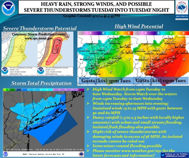
A coastal flood advisory, a severe thunderstorm warning, and a wind advisory that have been issued, along with the watch, equal a hazardous weather outlook.

The New York Yankees and New York Mets both postponed their evening games on Tuesday to later dates because of the inclement weather. 

The tornado watch, which was first issued until 7 p.m. in Northeast New Jersey and Southeast New York, including all five boroughs of New York City, is now in effect until 9 p.m..

Winds up to 55 miles per hour are included in the wind advisory, currently in effect until Wed. morning at 6 a.m. Potential impacts include downed tree limbs and power lines. The Weather Service encourages drivers to use extra caution.

<a href="https://www.theepochtimes.com/assets/uploads/2015/07/538732_502020506493936_1712605259_n.jpg"><img class="size-medium wp-image-293687" src="https://www.theepochtimes.com/assets/uploads/2015/07/538732_502020506493936_1712605259_n-532x450.jpg" alt="" width="350" height="296"/></a>

The western portion of the Long Island sound, jutting toward Manhattan, could flood low parts of Manhattan and Staten Island. The coastal flooding advisory, for possible tides between one and two feet “above astronomical,” is in effect from 9 p.m. Tuesday evening until 1 a.m. early Wednesday.

Yet the National Weather Service states the summary of hazardous weather events do not meet its “warning criteria.”

The alert on its Facebook page states: “Heavy rain and thunderstorms will move in from southwest to northeast between 6 PM and 10 PM, although isolated showers and thunderstorms could occur before then. Some thunderstorms could be severe with damaging winds and isolated tornadoes.”

The weather has been brought from the central and southern United States via a cold front. 

A pair of tornadoes hit New York City on Sept. 8, one with wind speeds of up to 110 miles per hour in Canarsie, Brooklyn, and another weaker one in Breezy Point, Queens. Some buildings on or close to the water sustained damage, but no deaths or injuries were reported.

The public is encouraged to visit www.weather.gov/nyc to keep up to date on the latest announcements.