An intensifying storm system is moving across the Northeast Thursday, bringing significant snowfall, gusty winds, cooler temperatures and severe storms.
As the storm moves off the coast, it will develop into a late-season nor'easter bringing feet of snow to interior New England through Friday.
It will pick up in intensity throughout the day Thursday.
“Winds will also become increasingly strong leading to near whiteout conditions and drifting snow,” the WPC says.
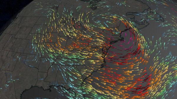
The overall wind threat associated with this storm system is broad.
Severe Storms Move Through New York at Midday
Winds will be even stronger in the line of storms that develops along the cold front that trails to the south of the storm’s low-pressure center.This line of severe thunderstorms will rush through the Northeast metros about midday.
“A line of storms will move through early this afternoon, bringing the threat for damaging winds,” says CNN meteorologist Dave Hennen.
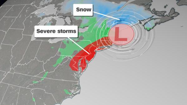
The Storm Prediction Center has issued a severe thunderstorm watch that includes the New York City, Philadelphia, Baltimore and Washington metro areas until 4 p.m. this afternoon.
“The strongest storm could bring damaging winds of up to 70 mph and may bring power outages to the region,” Hennen says.
Storms Will Develop in Texas on the Southern Side of the Storm
The tail end of the front stemming from the Northeast storm will lead to intense storms this afternoon.In parts of southeast Texas, the threat for severe storms is higher, where an enhanced risk—level 3 of 5—exists south of Houston.
“Storms will fire midafternoon over central Texas and spread towards the southeast with damaging winds and hail,” Hennen says. “Even an isolated tornado is possible.”
After a break on Friday, storms will return this weekend.
Storms will begin on Saturday in Texas.
Cooler Air Will Rush in Behind Thursday’s Cold Front
A colder and drier air mass will rush in behind the cold front on Thursday.“By Friday, much of the eastern half of the country will be 10 to 20 degrees below normal,” Hennen says.
This will last through week’s end.