Scientists Discover Massive Impact Crater That May Coincide With End of Ice Age

Simon Veazey
11/15/2018
Updated:
11/15/2018

Scientists have discovered a massive impact crater under the ice sheet in Greenland that might have been formed at the end of the Ice Age.

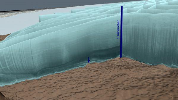
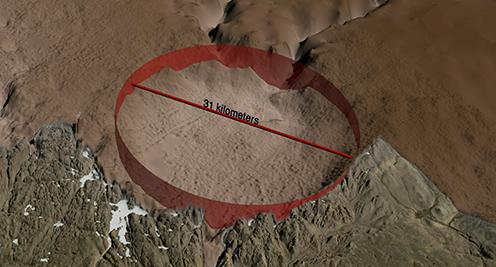
Hidden under a half-mile of ice, the 19-mile-wide, 1,000-foot-deep impact crater is one of the 25-largest ever discovered, and according to NASA, probably one of the youngest.

Scientists believe the Hiawatha crater was created when an iron meteorite more than a half-mile wide smashed into western Greenland with the force of about 47 million Hiroshima bombs. It may have been formed as recently as 12,000 years ago, around the end of the last Ice Age, stirring interest from those who theorize that an advanced prehistoric civilization was wiped out by a natural disaster around that time.

In 2015, Danish scientists noticed a large circular depression in NASA images that used radar to penetrate the ice sheet and model the surface of the Earth.

Radar data from an intensive aerial survey of the Hiawatha crater in May 2016, in aqua-colored curtains. A blue arrow points to the central peak of the crater. (Cindy Starr/NASA)
“We immediately knew this was something special but, at the same time, it became clear that it would be difficult to confirm the origin of the depression,” said Kurt Kjær, a professor at the Center for GeoGenetics at the Natural History Museum of Denmark in a statement.

Exceptionally Well-Preserved

They started a three-year investigation, and, on Nov. 14, published their findings in the journal Science Advances.

They found quartz crystals near the site that displayed signs of violent impact.

“The crater is exceptionally well-preserved and that is surprising because glacier ice is an incredibly efficient erosive agent that would have quickly removed traces of the impact,” said Kjaer, lead author of the study.

“So far, it has not been possible to date the crater directly, but its condition strongly suggests that it formed after ice began to cover Greenland, so younger than 3 million years old and possibly as recently as 12,000 years ago—toward the end of the last Ice Age.”

Map of the bedrock topography beneath the ice sheet and the ice-free land surrounding the Hiawatha impact crater. The structure is 31 km wide, with a prominent rim surrounding the structure. In the central part of the impact structure, an area with elevated terrain is seen, which is typical for larger impact craters. (Natural History Museum of Denmark.)

The team also found evidence of disturbance in the ice flow around the end of the last Ice Age.

Kjaer said the next step is to date the impact. “This will be a challenge, because it will probably require recovering material that melted during the impact from the bottom of the structure, but this is crucial if we are to understand how the Hiawatha impact affected life on Earth.”

Wiping Out an Advanced Civilization?

The discovery prompted great interest among those who believe that prehistoric civilizations existed, but they were destroyed in natural disasters along with most of the evidence of their existence.

Graham Hancock, who has, for decades, claimed that archaeological evidence points to a previous civilization before the last Ice Age, wrote, “Further evidence for the cosmic impact that caused a global cataclysm near the end of the last Ice Age and perhaps wiped an entire advanced civilization from the record.”

The finding was sparked by NASA images that are made freely available to scientists and the public all around the world, according to Joe MacGregor, a NASA glaciologist.

“Previous radar measurements of Hiawatha Glacier were part of a long-term NASA effort to map Greenland’s changing ice cover,” MacGregor said in a statement. “What we really needed to test our hypothesis was a dense and focused radar survey there. The survey exceeded all expectations and imaged the depression in stunning detail: a distinctly circular rim, central uplift, disturbed and undisturbed ice layering, and basal debris—it’s all there.”
Simon Veazey is a UK-based journalist who has reported for The Epoch Times since 2006 on various beats, from in-depth coverage of British and European politics to web-based writing on breaking news.
twitter
Related Topics