The Chinese regime is using the Mekong River, the most important water system in Southeast Asia, to control half of the ten member countries of the Association of Southeast Asian Nations (ASEAN), an expert said.
In fact, for more than a decade since 2010, water crises have often erupted on the Mekong River.
A Chinese hydrologist tells The Epoch Times that one of the reasons behind this is that the Chinese Communist Party (CCP) has taken control of the “water tap” of the Mekong, and that the Mekong River has become a political bargaining chip for the CCP to use in controlling half of the ten countries of ASEAN.
During a recent exclusive interview with The Epoch Times, German-based hydrology expert Wang Weiluo said that ever since 2010, the Mekong River has been experiencing frequent water crises. But for the CCP, the Mekong River is no longer simply an issue of water resource utilization, but more of political and diplomatic leverage.
From Water Abundance to Water Crises
The upper reach of the Mekong River is the Lancang River inside China. It originates in the Tanggula Mountains on China’s Qinghai-Tibet Plateau. As the world’s tenth, and Asia’s sixth-longest river, the Mekong flows through six countries including China, Myanmar, Laos, Thailand, Cambodia, and Vietnam, before eventually flowing into the South China Sea.The lower reaches of the river and the upper reaches of the river are collectively known as the Lancang-Mekong River, which has a main section of more than 4,000 kilometers (2,485 miles). It is the longest river in Southeast Asia, and is known as the “Danube of Asia.”
“Both the Lancang and Mekong rivers are originally very rich in hydropower resources,“ Wang said, ”They come directly from the Tibetan Plateau to the south, and the slope of the upper reaches is very steep. In the southern part of the lower reaches, due to the influence of the monsoon, the relatively abundant rainfall during the rainy season also makes the rivers more water-rich. The Mekong River has a distinct dry and rainy season, with the dry season generally lasting from November to April and the rainy season from May to October.”
However, this river, which was originally rich in water resources, has been experiencing frequent water resource crises since 2010.
By simulating the flow of the Mekong River from 1992 to 2019, and comparing the data before and after the dams were built, Eyes on Earth points out that the construction of upstream dams by the CCP has affected the volume of water in the Mekong River.
According to the report, “Considerable differences in measured and predicted flow occurred in 2010, when the major Xiaowan dam was completed and the generators came online.”
Number Games to Shift Responsibilities
In 2010, Thailand, Laos, Vietnam, and Cambodia sent delegates to the CCP to discuss the serious drop in water levels in the Mekong River, arguing that CCP’s dams on the river were causing the drought downstream.Qin Gang, the CCP’s Ministry of Foreign Affairs spokesman at the time, denied the claim. Qin Gang claimed that the annual flow of the Lancang River was only 13.5 percent of the Mekong’s flow to the sea, and with such a small percentage, it could not affect the overall situation.
The CCP’s political counsellor Chen Dehai also said that the three reservoirs built along the Lancang River, namely Manwan, Dachaoshan, and Jinghong, were all very small, and their impact was not significant.
But Wang says that these are just number games the CCP played to dodge responsibilities. Much of the data on China’s rivers are kept secret. Even the disclosed data are often contradictory.
Wang said, for example, the average annual outflow of the Lancang River at China’s border is about 64 billion cubic meters, but there is another estimate that puts it at 76 billion cubic meters, a difference of 12 billion cubic meters of water.
If one takes 76 billion cubic meters as the true number, the annual flow of the Lancang River would be 16 percent of the Mekong’s flow to the sea, and there would be a difference of 2.5 percent compared with the 13.5 percent claimed by Qin Gang.
According to Wang, the CCP once also claimed that China has 18.6 percent of the water rights of the Lancang-Mekong River, meaning that 18.6 percent of the water resources belong to China.
So the point is, the CCP’s numbers about Lancang-Mekong River keep changing, from 13.5 percent to 16 percent, and then to 18.6 percent.
When discussing rights, the CCP chose 18.6 percent, but when it comes to accountability, it chose 13.5 percent.
Wang said, even if the real number is 13.5 percent, it does not mean that the CCP does not have to bear any responsibilities.
However, in most of the river sections inside China, such as at the Luang Prabang section, the outbound flow from China accounts for about two-thirds of the total water amount of Mekong.
Wang also explained, “The figure 13.5 percent is meaningless, as you are measuring the amount of water at Sai Kung, the mouth of Mekong to the South China Sea, so it is 13.5 percent. But the right way to measure it is to look at the section of the river near China, that is, the section right after the Lancang River flows out of China. That is, if you check the river section that is just out of China, and within 300 kilometers from the Chinese border, you will find that 2/3 of the water comes from the upper reaches of China. If you stop the water inside China, the people downstream will scream that they don’t have any water coming down.”
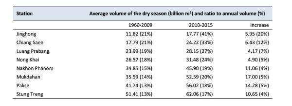
When analyzing the impact of the dams on the Mekong River, the report says, “Using monthly average discharge of 1960–2009 and 2010–2015, average volume for the dry season (Dec. to May) was evaluated at Jinghong and seven other hydrological stations along the Mekong River. The results show that the operation of the Lancang cascade dams increased dry season volume at Jinghong from 11.82 billion m3 (or 21 percent of annual volume of 1960–2009) to 17.77 billion m3 (or 41 percent of annual volume of 2010–2015), contributing 5.95 billion m3 (or 20 percent).”
Qin Hui also criticized the Chinese officials for saying that there are only “three reservoirs” on the Lancang River, namely Manwan, Dachaoshan, and Jinghong, while not mentioning the Xiaowan Reservoir, which has a capacity of more than 15 billion cubic meters.
The Xiaowan Hydropower Station started to generate electricity in September 2009. The capacity of Xiaowan Reservoir is almost five times the combined capacity of Manwan, Dachaoshan, and Jinghong, which has a significant impact on the downstream flow.
Qin Hui questioned, “How come it became ‘almost having no impact’ in the mouth of officials?”
A Helping Hand or Political Bargaining Chip?
While the CCP chose to ignore the drought in the Mekong River Basin in 2010, it went out of its way to offer help six years later.In 2016, Vietnam, known for its rice and fishery products, experienced a severe drought, with some coastal areas encroached by seawater due to a reduction in river water.
According to Chinese state media outlet Xinhua, the CCP extended a helping hand to the lower Mekong countries. Lu Kang, the Chinese Foreign Ministry spokesman at the time, said at a press conference that China would provide emergency water supply to the lower Mekong River from March 15, 2016, to April 10, 2016, through China’s Yunnan Jinghuang Power Station in Yunnan Province.
In October of the same year, the report issued jointly by Mekong River Commission and Ministry of Water Resources of China stated that the release of water from the cascade dams built by the CCP in the upper reaches of the Mekong River helped raise the water level during the Mekong’s dry season.
The report says, “The operation of the Lancang cascade dams increased dry season volume at Jinghong from 11.82 billion m3 (or 21 percent of annual volume of 1960-2009) to 17.77 billion m3 (or 41 percent of annual volume of 2010-2015), contributing 5.95 billion m3 (or 20 percent).”
Wang told The Epoch Times that in 2016, during the CCP’s “disaster relief” period, the CCP released at least 1,000 cubic meters per second of water into the lower reaches of the Mekong River every day, and the maximum release was more than 2,000 cubic meters per second, while the natural flow of the Lancang River was around 400 cubic meters per second at that time.
This means that the scale of China’s water release exceeded the flow of the Lancang River during the dry season, and was five times the natural flow of the lower reaches.
This also means that China has taken control of the “water tap” of the Mekong River.
Wang said it is worth noting that the Chinese water transfer to the lower Mekong River was made by the Chinese Flood Control and Drought Relief Command, which means that the CCP used the “disaster relief” fund to do it. It was Chinese taxpayers’ money, and it was the Chinese people who paid the bills for the CCP.
Wang said the reason why the CCP chose to lend a helping hand in 2016 was out of political considerations.
In 2014, Chinese Premier Li Keqiang proposed the establishment of the Lancang–Mekong Summit at the China–ASEAN Leaders’ Meeting.
Two years later, in March 2016, the first Lancang–Mekong Summit was held in Sanya city, Hainan Province, in China. Leaders from 5 countries of the Lancang-Mekong River region attended the summit. Xinhua reported the summit in a very high-profile manner and the CCP took the opportunity to show friendship by releasing water downstream.
In his speech at the meeting, Li Keqiang mentioned that it was necessary to build a “Community of Shared Future” among Lancang-Mekong countries, and that “China has signed or is negotiating with several Mekong countries the initiatives to build ‘One Belt, One Road’ projects. ”
Wang said that showing some good gestures was a political need for the CCP at that time. The “disaster relief” effort could also pave the way for the CCP to invest in Southeast Asian countries.
What Can the CCP Gain From Mekong Countries?
The Mekong Basin countries are relatively backward economically, but rich in natural resources. By investing in the Mekong River Basin, the CCP can not only expand international trade and export excess domestic capacity through the Belt and Road projects, but can also gain access to the rich natural resources of the Mekong River Basin countries.Take Laos as an example. According to the Guide to Foreign Investment Cooperation by Country issued by the Ministry of Commerce of China, Laos is rich in deposits of gold, copper, tin, lead, potassium, iron, gypsum, coal, and salt.
In the meantime, it is also rich in hydropower and forestry resources. Laos has about 17 million hectares of forests, with a national forest cover rate of about 50 percent.
It produces valuable timber such as teak, sourwood, and rosewood. China imports copper, timber, and agricultural products from Laos.
According to the Ministry of Commerce of China’s professional service platform Investgo.cn, China is also the largest investor in Laos, with investments in hydropower and mineral development.
According to China’s Ministry of Commerce, Cambodia, another country in the Mekong River Basin, is also rich in forestry, minerals, and fishery resources, including high-quality woods such as teak, ironwood, rosewood, and ebony, as well as many kinds of bamboo.
Cambodia’s mineral deposits include oil, natural gas, phosphate, gemstones, gold, iron, bauxite, etc.
Tonle Sap Lake in Cambodia is the largest natural freshwater lake in Southeast Asia and is known as a “Fish Lake.”
According to Investgo.cn, in 2019, the trade volume between China and Cambodia reached $9.43 billion, up 27.7 percent year-on-year.
And in the same year, Chinese enterprises signed $5.58 billion in new construction contracts in Cambodia, up 93.6 percent year-on-year.
According to Wu Fu-cheng, deputy director of the National Economic Development Strategy Center at the Taiwan Institute for Economic Research, the CCP has a strong geopolitical strategic purpose in the Mekong region. Its investment aims at building a strategic partnership with ASEAN and deepening the relationships between China and ASEAN.
What Kind of Harm Has the CCP Brought to the Lancang-Mekong River?
Wang said by turning the dams into a political bargaining chip, the CCP has done a lot of harm to the people of the Lancang-Mekong River Basin. Not only do they suffer from frequent droughts, but their fishing industries have also suffered a significant impact.Wang said after the reservoirs were built, the sediment, which contains nutrients for fish, could not settle down.
Moreover, the temperature of the water inside the reservoir is several degrees lower than that of the normal river water. The lower temperature disrupts fish breeding. Fishermen have been complaining that their harvest has been decreasing, and they worry that they will lose their basis of survival in the near future.
While people outside China are suffering, people inside China are not benefiting from the dams either.
According to Wang, the height of the dams on the Lancang River is very high, most of them are over 100 meters, and the highest one reaches 294.5 meters. So after the construction of the reservoirs, local farmers had to move up to the mountains, where the land is very poor and not suitable for farming.
Secondly, the local farmers’ irrigation water was restricted because the water in the Nuozadu and Xiaowan reservoirs was restrained by the hydropower stations.
Third, the subsidies provided by the CCP to the reservoir migrants actually came from the Chinese taxpayers, not from the money earned from the hydropower stations.
Wang also pointed out a problem that is often overlooked: the flooding of the Lancang River is relatively large, with a maximum measured flow peak of 12,800 cubic meters per second.
In the meantime, the Xiaowan Reservoir has a flood discharge capacity of 20,000 cubic meters per second.
If any problem occurs, for example, if the Xiaowan Dam breaks, or if the CCP chooses to release the water in the reservoir to reduce the pressure on the dam, people downstream, including those at the Mekong River basin, will be greatly threatened.
While the hydropower stations have brought a lot of damage and threat, some of the electricity generated goes to waste and is not used.
According to the Bureau of Statistics in Yunnan Province, due to overcapacity, 31.4 billion kilowatt-hours of hydropower were wasted in Yunnan Province in 2016, and hydropower stations on the Lancang River were facing the same problem.
Mekong River: A New Geopolitical Hotspot
In recent years, the international community has become increasingly aware of the threat posed by the CCP to Southeast Asian countries, and the United States and Japan have taken corresponding actions. The Mekong River has become a new geopolitical hotspot.The U.S. statement says, “Our relationship with Mekong partner countries is an integral part of our Indo-Pacific vision and our strategic partnership with ASEAN. “
According to the BBC, Stimson Center co-director Yun Sun said the catalyst for the United States to launch the program was China’s previous refusal to share hydrological information, as the data would reveal how the CCP operates the dams on the Lancang River.
One of the key reasons why the Mekong River has become a political bargaining chip for the CCP is the lack of information transparency. Although the CCP claimed in 2020 that it would share hydrological information on the Lancang River, it has not done so.
Wang said, “The normal international practice for transnational rivers is that the river basin countries basically follow three principles: first, to make fair and reasonable use of the water resources of the transnational rivers; second, not to cause significant damage to other countries; and third, to notify other countries in advance of any construction work on the rivers, and only after obtaining their consent can the work begin. “
Unfortunately, he said, the CCP doesn’t follow international norms, and it has become accustomed to not only keeping everything in the dark, but also doing everything in the dark.