")
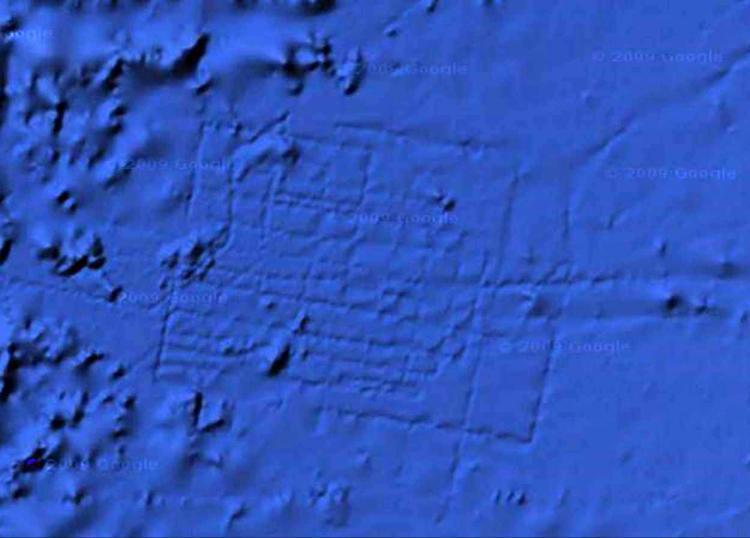
On the floor of the Atlantic Ocean, about 600 miles off the coast of northwest Africa, near the Canary Islands, lies a mysterious grid that was spotted by an English aeronautical engineer while using Google Earth 5.0 when it came out in 2009.
Bernie Bamford told the Daily Telegraph in a 2009 report that the network of lines must be “man-made,” likening it to the grid square design of Milton Keynes in England.
The rectangle is approximately 100 miles by 70 miles, equivalent in size to the country of Wales, and is situated at the exact coordinates of 31 15‘15.53N, 24 15’30.53W, about 3.5 miles below the ocean surface. In fact, there are other straight crisscrossing lines starting about 150 miles east of the street-like grid that Bamford discovered.
Dr. Charles Orser, curator of historical archaeology at New York State University, said the mysterious markings could be the remains of the lost island city of Atlantis, first mentioned in the dialogues of the Greek philosopher Plato, according to U.K. tabloid The Sun in 2009.
“The site is one of the most prominent places for the proposed location of Atlantis, as described by Plato,” Orser told The Sun. “Even if it turns out to be geographical, it definitely deserves a closer look.”
According to Plato, Atlantis was a naval power located “in front of the Pillars of Hercules”—the Strait of Gibraltar—that conquered parts of Western Europe and Africa around 9600 B.C. Plato described Atlantis as a land of great wealth and natural beauty, larger than Libya and Asia combined. But, after a failed attempt to invade Athens, Atlantis sank into the ocean, destroyed by earthquakes and floods.
However, Google said that the lines could be caused by sonar from the boat that collected the information.
“It’s true that many amazing discoveries have been made in Google Earth, including a pristine forest in Mozambique that is home to previously unknown species and the remains of an ancient Roman villa,” said Google in a 2009 statement, according to The Sun.
“In this case, however, what users are seeing is an artifact of the data collection process. Bathymetric (or sea floor terrain) data is often collected from boats using sonar to take measurements of the sea floor. The lines reflect the path of the boat as it gathers the data.”
But Google’s explanation does not account for the areas in between the lines.
“The fact that there are blank spots between each of these lines is a sign of how little we really know about the world’s oceans,” Google said.
The Epoch Times publishes in 35 countries and in 19 languages. Subscribe to our e-newsletter.