Irma Turns Into Most Powerful Atlantic Hurricane Ever Recorded Outside Gulf and Caribbean

Irma Turns Into Most Powerful Atlantic Hurricane Ever Recorded Outside Gulf and Caribbean
Hurricane Irma, a category 5 hurricane with maximum sustained winds near 185 mph with higher gusts, is shown in this GOES satellite image in the Atlantic Ocean east of the Leeward Islands and Puerto Rico and the Dominican Republic, on Sept. 5, 2017. (U.S. Navy photo/Handout via REUTERS)
NTD Television
9/5/2017
Updated:
9/5/2017

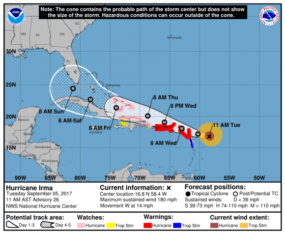
Hurricane Irma intensified into a monstrous storm on Tuesday, Sept. 5, with wind speeds of over 180 mph, making it the most powerful Atlantic storm ever recorded outside the Gulf of Mexico and the Caribbean, according to an 11 a.m. advisory from the National Hurricane Center (NHC).

Irma was upgraded at a Category 5 Hurricane earlier on Tuesday, with winds well above the 157 mph threshold for the category. Irma was moving toward the Leeward Islands at 14 mph as of the 11 a.m. advisory. The NHC called it an “extremely dangerous storm.”

Irma is a “Cape Verde hurricane,” which are known to be especially intense. Cape Verde hurricanes form far out over the Atlantic Ocean near the Cape Verde Islands. They then travel all the way over the Atlantic, according to CNN meteorologist Brandon Miller.

(NHC/NOAA)
(NHC/NOAA)

Cape Verde storms often turn into some of the most massive and intense hurricanes, including the likes of Hurricane Hugo, Hurricane Floyd, and Hurricane Ivan.

In its current state, Irma would be the biggest storm to hit Florida since Hurricane Andrew in 1992, according to the Miami Herald.

Irma could reach southern Florida on Sept. 10 as a Category 4 hurricane, according to a global model developed by National Oceanic and Atmospheric Administration (NOAA) and mapped by Ventusky.com.

NOAA global model forecast for Sept. 10 mapped by Ventusky.com with data available at 1 p.m. on Tuesday, Sept. 5, 2017. (Ventusky.com)

Florida Gov. Rick Scott declared a state of emergency in all 67 Florida counties on Monday and activated the National Guard on Tuesday, with 7,000 members set to report for duty on Friday.

“With Hurricane Irma now a category 5 storm, we must do all we can to prepare our families and communities for any potential impact from this major weather event,” Scott said in a statement.

“We do not know the exact path of this storm, but weather can change in an instant and while we hope for the best, we must prepare for the worst,” Scott added.

Scott said on Tuesday, he also asked President Donald Trump for a prelandfall emergency declaration to obtain more federal funds and resources.

A Category 5 hurricane on the five-step Saffir-Simpson scale means sustained winds of more than 157 mph and “catastrophic” outcomes. They range from uprooted trees and downed power lines to water and electricity outages and enough damage to leave property uninhabitable, according to the Miami-based hurricane center.

Irma’s size has reached a level where Florida would be affected by its winds even if it does not make landfall.

“If ever there was a storm to take seriously in the Keys, this is it,” Monroe County Emergency Management Director Martin Senterfitt told the Miami Herald. “The sooner people leave, the better.”

Reuters contributed to this report.

From NTD.tv