Hurricane Michael Forms: Now a Category 1 Storm

Jack Phillips
10/8/2018
Updated:
10/8/2018

Hurricane Michael is now a Category 1 storm system and is tracking toward the northwestern coast of Florida, according to an 11 a.m. update from the U.S. National Hurricane Center (NHC) on Oct. 8.

The NHC has forecast that Michael is slated to strengthen and will bring heavy rains, damaging winds, and storm surge. There is a likely chance that it will hit the northeastern Gulf Coast by Oct. 10. The path of the storm could take it directly through Florida’s capital, Tallahassee.
Florida Gov. Rick Scott on Oct. 7 declared a state of emergency for several areas in Florida and “also directed the Florida National Guard to activate 500 guardsmen to assist with planning and logistics, and to prepare for response in impacted areas.”
Hurricane Michael's path to Florida and Alabama as of 11 a.m. on Oct. 8. (NHC)

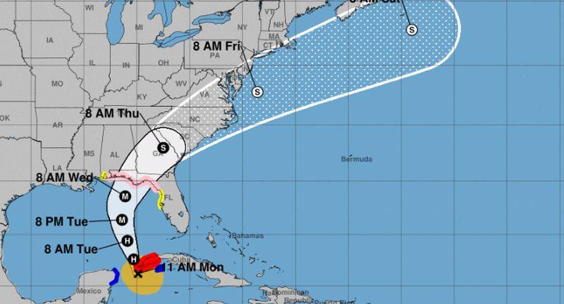
Currently, the storm has 75 mph winds and is 50 miles south of the western tip of Cuba and 140 miles east-southeast of Cozumel, Mexico, the hurricane forecasting agency said.

A hurricane warning is in effect for Pinar del Rio, Cuba, and a tropical storm warning is in effect for the Cuban province of the Isle of Youth and the coast of Mexico from Tulum to Cabo Catoche, including Cozumel.

A hurricane watch is in effect for the Alabama-Florida border to Suwannee River in Florida. A tropical storm watch is in effect for Suwannee River to Anna Maria Island Florida, including Tampa Bay as well as the Alabama-Florida border to the Mississippi-Alabama border, according to the NHC.

“Interests elsewhere across the southeastern United States should monitor the progress of Michael,” the agency warned.

The NHC’s forecasted “cone of uncertainty“ shows that the storm will hit Florida’s Panhandle region before going through Alabama, Georgia, South Carolina, and North Carolina.
“The satellite presentation of Michael has continued to improve overnight and this morning, with the center well embedded within an area of cold cloud tops. An eye is becoming apparent in visible imagery,” reads a discussion from the NHC at 11 a.m.

State of Emergency

Scott’s office declared a state of emergency in Escambia, Santa Rosa, Okaloosa, Walton, Holmes, Washington, Bay, Jackson, Calhoun, Gulf, Gadsden, Liberty, Franklin, Leon, Wakulla, Jefferson, Madison, Taylor, Hamilton, Suwannee, Lafayette, Dixie, Columbia, Gilchrist, Levy and Citrus counties.
“That means the Panhandle and Big Bend can see winds in excess of 100 mph. Remember, this storm could grow stronger and be a Category 3 hitting our state. This storm will be life-threatening and extremely dangerous,” Scott said, according to ActionNewsJax.
“Take this seriously and keep your family safe,” he also stated, according to the Tallahassee Democrat. “We know that a storm like Michael can be devastating and deadly.”

NHC Director Ken Graham warned that Hurricane Michael’s winds could reach at least 100 mph or higher as the storm approaches the coast on Oct. 10.

“We’ve got a few days to do that as this storm continues to strengthen,” Graham said. “Upwards of 100 mph winds, could be greater than that, Category 2 or Category 3, so we’ve got to be prepared for that. We are predicting a very strong hurricane to get into the Gulf of Mexico.”

Jack Phillips is a breaking news reporter with 15 years experience who started as a local New York City reporter. Having joined The Epoch Times' news team in 2009, Jack was born and raised near Modesto in California's Central Valley. Follow him on X: https://twitter.com/jackphillips5
twitter
Related Topics