Hurricane Florence Is a ‘Horrific Nightmare’ to Predict, Says Forecaster

Jack Phillips
9/13/2018
Updated:
9/13/2018

One weather forecaster says Hurricane Florence is a “nightmare” to predict.

“This is a horrific nightmare storm from a meteorological perspective,” University of Georgia meteorology professor Marshall Shepherd told The Associated Press. “We’ve just never seen anything like this. ... This is just a strange bird.”

According to some forecasts, Florence is predicted to slow down and stall off the coast of North and South Carolina before moving around off the shore on Sept. 14, Sept. 15, and Sept. 16. Then the storm is slated to affect Georgia, Tennessee, Virginia, Alabama, and Kentucky before moving north, according to the U.S. National Hurricane Center’s forecasting model.

Florence is predicted to slow down and stall off the coast of North and South Carolina before moving around off the shore on Thursday (Sept. 14), Friday (Sept. 15), and Saturday (Sept. 16). (NHC)

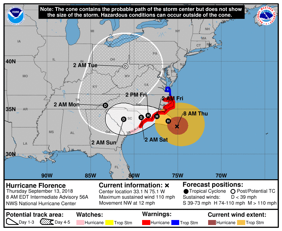
The NHC said that between 20 and 30 inches of rain could fall in some areas. If the storm lingers longer, more rain will fall, according to forecasters.

“For a meandering storm, the biggest concern—as we saw with Harvey—is the huge amount of rainfall,” said Chris Landsea, chief of tropical analysis and forecast branch at the National Hurricane Center. He’s referring to Hurricane Harvey, which inundated some parts of southern Texas with 60 inches of rain in 2017.

Ryan Maue, a meteorologist for Weathermodels.com, tweeted that “the rainfall will add up quickly across the Carolinas but also Virginia” after Florence hits the region. “I'd bet on maximum totals > 30” in many counties ... forecast totals from the adjacent states near landfall around 17 trillion gallons,” he added.

U.S. weather officials said Florence weakened to a Category 2 storm, but the storm, according to NASA in a blog post on Sept. 12, is still more than 400 miles in diameter.

“Florence core winds dropping but the storms strong wind is spreading out, Eye trying to reform, A big dangerous widespread storm. It’s here where Saffir-Simpson may not be best measure of storms true power,” tweeted Weatherbell.com meteorologist Joe Bastardi.
He’s referring to the Saffir-Simpson Hurricane Wind Scale, which measures the strength of hurricanes in categories. A Category 2 hurricane has 111 mph to 129 mph winds.

“It certainly is a challenge forecasting precise impacts when its exact track won’t be known until a day in advance,” Landsea told AP.

“It’s going to coming roaring up to the coast Thursday night and say ‘I’m not sure I really want to do this and I’ll just take a tour of the coast and decide where I want to go inland,'” said Jeff Masters, who is the meteorology director of the private Weather Underground website, AP reported.

“The satellite presentation of Florence has changed little overnight with the eye waxing and waning in infrared imagery,” according to the NHC’s discussion of the hurricane.

It added: “As mentioned in the previous discussion, it appears that some southern shear has caused the degradation of the inner core. The global models suggest that this shear will relax today while Florence moves over warm waters, however, given the current storm structure, little overall change in strength is anticipated as Florence approaches the coast.”

Did you enjoy this article? Continue to read more stories  here.

Jack Phillips is a breaking news reporter with 15 years experience who started as a local New York City reporter. Having joined The Epoch Times' news team in 2009, Jack was born and raised near Modesto in California's Central Valley. Follow him on X: https://twitter.com/jackphillips5
twitter
Related Topics