Here Is What Miami May Look Like on Sunday Morning

Here Is What Miami May Look Like on Sunday Morning
In this NOAA handout image, NOAA's GOES satellite shows Hurricane Katia (L) Hurricane Irma (C) and Hurricane Jose (R) on September 7, 2017 in the Atlantic Ocean. (Photo by NOAA GOES Project via Getty Images)
Ivan Pentchoukov
9/8/2017
Updated:
9/8/2017

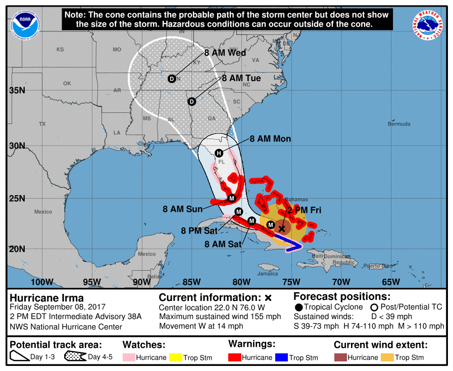
As Hurricane Irma bears down on the entire state of Florida, Miami could be facing catastrophic flooding, with one simulation estimating the entire city to be underwater in a worst-case scenario.

A video simulation by Climate Central shows downtown Miami completely inundated with flood water. The U.S. National Hurricane Center (NHC) estimates that coastal areas in Florida may see up to 12 feet of storm surge as waters rise in connection with Hurricane Irma.

Floods will hit the southwestern coast of Florida from Captiva to Cape Sable the hardest, the NHC said in a 2 p.m. advisory released on Friday, with the water rising 6-12 feet above ground level.

The area from Jupiter Inlet to Cape Sable, including the Florida Keys will see water levels rise 5 to 10 feet. Meanwhile, the stretch of coast from Ponce Inlet to Jupiter Inlet and from Venice to Captiva will see storm surges of 3 to 6 feet, NHC said.

(NHC/NOAA)
(NHC/NOAA)

The worst flooding is likely to occur if the peak surge from the storm occurs during the high tide.

“The deepest water will occur along the immediate coast in areas of onshore winds, where the surge will be accompanied by large and destructive waves,” the NHC said in the advisory.

The amount of flooding depends on a number of factors and the NHC is advising residents to check with the local National Weather Service for a more precise forecast.

Satellite imagery shows Hurricane Irma as it moves towards the Florida Coast as a category 4 storm in the Caribbean Sea taken at 14:45 UTC on Sept. 08, 2017. (NOAA GOES Project via Getty Images)

Hurricane Irma was moving west at 14 mph as of the 2 p.m. advisory with maximum sustained winds blowing at 155 mph. The storm is expected to remain a powerful Category 4 hurricane as it approaches Florida.

In addition to the flooding from the storm surge, Irma will dump up to 20 inches of rain in Florida, Georgia, South Carolina, and Western North Carolina. Upper Florida keys will see the most precipitation with between 10 and 15 inches of rain, according to the NHC. Isolated areas in the Upper Keys will get up to 20 inches.

“In all areas this rainfall may cause life-threatening flash floods and, in some areas, mudslides,” the NHC said.

(NHC/NOAA)
(NHC/NOAA)

Showers and thunderstorms associated with Hurricane Irma will begin in Florida on Friday evening and continue Saturday night into Sunday, according to the National Weather Service.

From NTD.tv

Ivan is the national editor of The Epoch Times. He has reported for The Epoch Times on a variety of topics since 2011.
twitter