Recent forecasts show that an El Nino that may happen this year would be a big one.
El Nino is named for warm waters that occasionally occur in the Pacific Ocean near South America.
The waters bring fluctuating weather around the world, including extreme weather events such as droughts and flooding.
“We’re carefully watching the potential development of an El Niño later this spring and into summer,” said weather forecaster Tony Barnston of the International Research Institute for Climate and Society in a recorded briefing message. “Below the surface we have a lot of warming and that could eventually make its way to the surface and create an El Niño.”
“We have above-normal temperatures in the tropical Pacific Ocean and that often precedes an El Niño because there’s a large volume of above-average water temperature below the surface of the ocean,” added Barnston to ABC. “Volume often tends to come up to the surface; often, but not always.
“That’s the uncertainty,” Barnston said. “It’s more likely to rise than not.”
He said that there’s a 70 percent probability of the United States experiencing an El Nino this year.
An official outlook will be published by the institute and the Climate Prediction Center.
If the El Nino does persist then it will develop between now and June and last until the start of next year.
ABC Meteorologist Melissa Griffin said that the El Nino could make 2014 the warmest year internationally on record, and 2015 even warmer.
“The most commonly accepted definition of an El Niño is a persistent warming of the so-called ‘Niño3.4’ region of the tropical Pacific Ocean south of Hawaii, lasting for at least five consecutive three-month ’seasons,'” wrote weather analyst Eric Holthaus.
“A recent reversal in the direction of the Pacific trade winds appears to have kicked off a warming trend during the last month or two. That was enough to prompt U.S. government forecasters to issue an El Niño watch last month.”
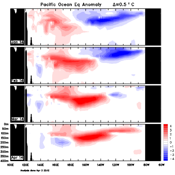
That giant red blob is a huge sub-surface wave of anomalously warm water that currently spans the tropical Pacific Ocean–big enough to cover the United States 300 feet deep. (Australia Bureau of Meteorology)
“As that blob of warm water moves eastward, propelled by the anomalous trade winds, it’s also getting closer to the ocean’s surface,” he said.
“Once that happens, it will begin to interact with the atmosphere, boosting temperatures and changing weather patterns.”
The mass of warm water is on par with that of what ended up being the biggest El Nino ever recorded, in 1997 and 1998.
That catastrophic event caused $35 billion in damage and left about 23,000 dead.
Among the predicted impacts of El Nino is the worsening of a severe drought in Indonesia, a signficant negative impact on Peru’s anchovy trade, and more wildfires in Australia.
In the United States, El Nino could bring a wetter-than-normal season on the West Coast and the south, but it could also bring too much rain and thus flooding and mudslides.