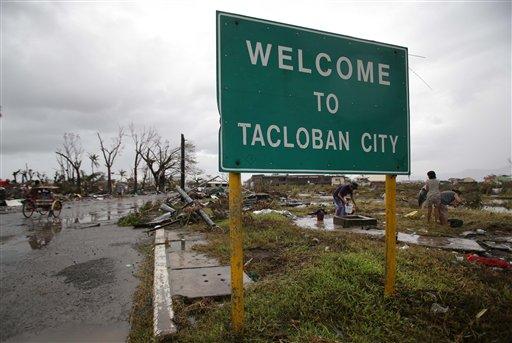
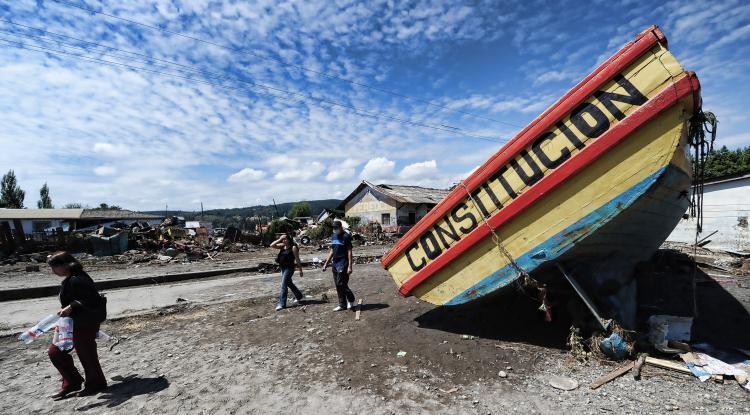
Chile Quake Tilts Earth’s Axis

Chile has experienced 13 events of magnitude 7.0 or greater since the 1970s.
Chile Quake Tilts Earth’s Axis
A boat grounded by the tsunami March 2, 2010 in the fishing village of Constitucion, central Chile. (Martin Bernetti/AFP/Getty Images)
3/2/2010
Updated:
10/1/2015

<a><img src="https://www.theepochtimes.com/assets/uploads/2015/09/97370707.jpg" alt="A boat grounded by the tsunami March 2, 2010 in the fishing village of Constitucion, central Chile. (Martin Bernetti/AFP/Getty Images)" title="A boat grounded by the tsunami March 2, 2010 in the fishing village of Constitucion, central Chile. (Martin Bernetti/AFP/Getty Images)" width="320" class="size-medium wp-image-1822500"/></a>
A boat grounded by the tsunami March 2, 2010 in the fishing village of Constitucion, central Chile. (Martin Bernetti/AFP/Getty Images)
While scientists and geophysicists around the world are researching ways to identify when an earthquake may occur, it is still not possible to predict the exact time and magnitude of an earthquake. However, what is known is that certain places on the planet are always at risk from big tremors. Chile is one of those places.

One of the most seismically active areas on the planet, Chile has experienced 13 events of magnitude 7.0 or greater since the 1970s.

In 1960, it also experienced the world’s strongest quake, magnitude 9.5, which, in combination with tsunami waves and earthquake devastation, left 1,655 dead and 2 million homeless.

Chile lies on a zone of quake and volcanic instability that encircles the Pacific Ocean known as the “Ring of Fire.”

Tilts Earth’s Axis

Argentina experienced a quake of magnitude 6 just hours after Chile’s quake, while Japan had experienced one of magnitude 7 the day before. Tonga, Fiji, Indonesia, and Ecuador are just some of the other Pacific nations that are regularly rumbling away, but the Chile quake was exceptional.

According to NASA, because of its position in the mid-latitudes (as opposed to the equator) and the steep angle at which the fault dips into the earth, the Chile quake actually shifted the Earth on its axis.

NASA Research scientist Richard Gross computed how Earth’s rotation should have changed as a result of the Feb. 27 quake.

“[Mr.] Gross calculates the quake should have moved Earth’s figure axis (the axis about which Earth’s mass is balanced) by 3 inches. Earth’s figure axis is not the same as its north-south axis; they are offset by about 33 feet,” the NASA Web site states.

Mega-Thrust Quake

Described as a “mega–thrust” earthquake, the Chile quake involved a tectonic clash offshore and around 20 miles underground between two of the world’s most active plates, the Nazca and the South American plates.

The Nazca, which is estimated to be around 62 miles thick, is being pulled eastward, grinding under the South American tectonic plate at a rate of about 80 millimeters (3.15 in.) per year.

The intensity of this constant process is evident in its creation of the spectacular Andes Mountains and the lesser known Peru-Chile trench, which spreads 2,300 miles along the eastern Pacific with depths up to five miles.

Over the years, however, the two plates had become locked.

French and Chilean seismologists had just competed research on the effects this impasse was having on the surrounding land, noting that a big quake was only a matter of time.

On Saturday, Feb. 27 at about 1:30 a.m. EST, the two plates suddenly became unlocked, slipping past each other and releasing 50 gigatons of energy along an almost 250 mile front.

“This earthquake fills in an identified seismic gap,” Dr. Roger Musson, the British Geological Survey’s Head of Seismic Hazard, told BBC News.

Seismologists will take note of the Chilean data as there are many other places overdue for a release, not the least of which is California.

“Its not a matter of if, only of when an event like this strikes the people of the United States, Marcia McNutt, director of the U.S. Geological Survey, said of the Chile quake in USA Today. “Shame on us if we don’t prepare.”