")
A tsunami warning was issued by the U.S. government’s Pacific Tsunami Warning Center following a large earthquake, measuring 7.6 on the Richter scale, which hit near the island nation of Vanuatu in the South Pacific Ocean.
“The Pacific Tsunami Warning Center has issued a non-expanding regional tsunami warning for a part of the pacific near the earthquake,” the center said in a statement. There is apparently no tsunami threat to Hawaii, but “some coastal areas in Hawaii could experience small non-destructive sea level changes and strong or unusual currents lasting up to several hours.” The sea level changes are expected to begin at 10:51 a.m. HST.
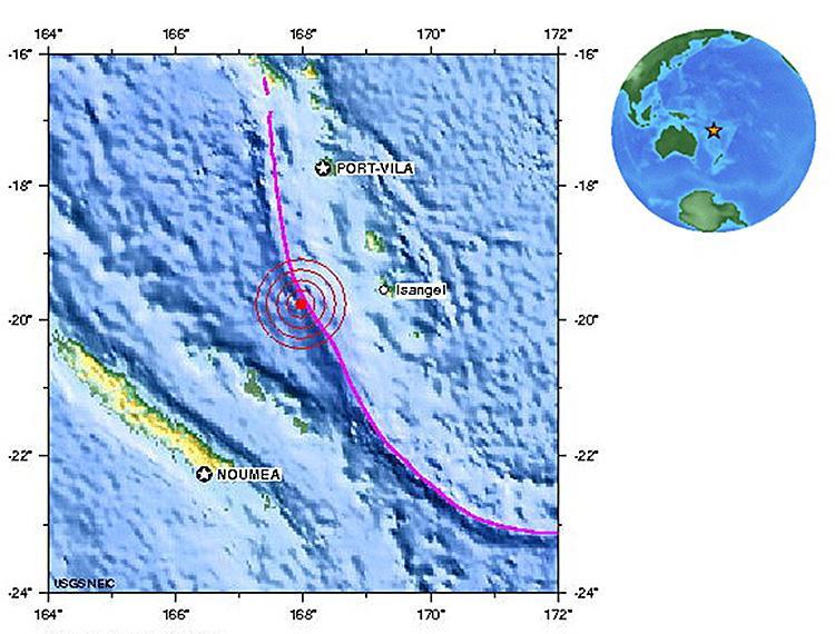
The earthquake struck 135 km (85 miles) west of Isangel, Vanuatu, or 1740 km (1090 miles) east-north-east of Brisbane, Australia, according to the USGS website. As ocean earthquakes go, it was shallow, at a depth of only 24.4 km (15.2 miles).
“The Pacific Tsunami Warning Center has issued a non-expanding regional tsunami warning for a part of the pacific near the earthquake,” the center said in a statement. There is apparently no tsunami threat to Hawaii, but “some coastal areas in Hawaii could experience small non-destructive sea level changes and strong or unusual currents lasting up to several hours.” The sea level changes are expected to begin at 10:51 a.m. HST.
The earthquake struck 135 km (85 miles) west of Isangel, Vanuatu, or 1740 km (1090 miles) east-north-east of Brisbane, Australia, according to the USGS website. As ocean earthquakes go, it was shallow, at a depth of only 24.4 km (15.2 miles).