
The new study published in the journal Scientific Data offers valuable insight into the historical trends that have shaped urbanization thought history. We spoke with lead author Meredith Reba, Yale University, about the study and how it can help us understand today’s cities.
ResearchGate: What motivated you to map out this data? What did you discover?
Meredith Reba: We wanted to look at some common questions: have cities located in fertile agricultural land grown the fastest and biggest historically? Have the earliest “big cities” all been located in prime agricultural areas? If so, what does this tell us about contemporary and future patterns of urbanization, as cities become disconnected from their agricultural bases?
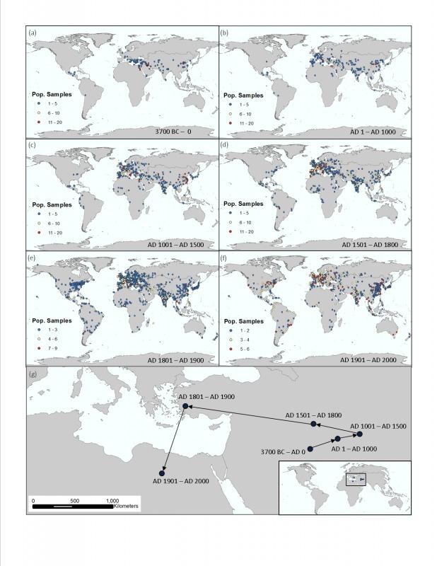
The global mean centers (GMC), the geographic centers, of global city populations have changed a lot overtime. GMCs show the center of a region’s population at a given point in time and can be useful in tracking human settlement patterns and large, global scale shifts over time. Given a specific time period, a GMC basically averages the latitude and longitude values of all cities in the dataset and weighs that average by each city’s population. Therefore, cities with a larger population can have a stronger “pull” on the GMC. For example, the center of the U.S. population in 2010 according the U.S. Census Bureau was in Texas County, Missouri, which is east of the actual center of the United States due to a larger population inhabiting the eastern side of the country. The GMC provides some indication of relative power, resource use, level of institutions and governance, and economic development, since cities with large populations required all of the above in order to develop and expand.

Our analysis shows that the GMC has mainly shifted west from Mesopotamia. In grade school we are taught that Mesopotamia is the cradle of civilization, and this study shows that the center of urban development shifted geographically over time. It also suggests that the geographic center of “urban civilization” doesn’t remain constant. We need to keep this in mind as we enter a century where we will experience large-scale urbanization: the urban center of power will continue to shift.

We also mapped the first recorded population value for each city in the dataset. Here, the spatial coverage of points pictured represents all cities included in the final dataset. Cities recording the earliest first population datapoint are pictured in red and are centered near Mesopotamia, while cities with the most recent first population datapoint are pictured in dark blue. It is important to note that the first population point for each city does not necessarily indicate its time of origin as a city.

RG: Where did you get your data from? And how much confidence do you have in its accuracy?
Reba: We used two separate established published datasets that were developed by a historian, Tertius Chandler, and a political scientist, George Modelski. Both datasets were available only in text form and had not been geolocated, synthesized, or harmonized. Although they were published, they were not easily usable or accessible.
We have high confidence in the accuracy of the data, but also recognize that it has some errors, a few of which we have found. We know that the final dataset is temporally and spatially sparse. Temporally, there are gaps in measured or interpolated population values that are hundreds or thousands of years in duration. Spatially, datapoints are also sparse for South Asian, South American, North American, and African cities. The dataset highlights the population values of important global cities during important time periods. Some of Chandler’s and Modelski’s population interpolation methods have also been critiqued such as the development of multipliers to interpolate population values, the use of soldiers to estimate city size, and the use of now outdated archeological records and methods. Limitations of the dataset are clearly outlined in the manuscript. However, we view this dataset as an important beginning compilation of a richer historical, global, city-level population database.
RG: Why is the dataset important? How does it help us better understand cities and population trends?
Reba: Before mapping this data, the only spatially explicit data available at a global scale was the United Nations World Urbanization Prospects, which provides population values, latitudes, and longitudes for places with populations of 300,000 or more, but only dated back to 1950 A.D. Here, the earliest urban settlement population dates back to 3700 B.C. This dataset can be used to look at time-slices of global populations for specific years or eras to determine regions of higher population density—or the data can be subset for specific countries, regions, or continents based on current or past border delineations. We can also look at population fluctuations of individual cities.
For example, Istanbul, Turkey (formerly Constantinople) underwent a major period of population decline between 1057 A.D. and 1453 A.D. During this time the population dropped from approximately 300,000 to 45,000 due to a series of events including a city sacking by the Crusaders and a bout with the plague, while an earthquake and eruptions of Mt. Etna led to numerous oscillations in the population of Catania, Italy throughout history. Outbreaks of disease, natural disasters, fires, and battles/wars can be marked by some population shifts in the dataset and are good examples of how a geographic environment can shape urban populations and population dynamics. By spatially locating these cities, we can better understand the drivers of population changes, and conversely, the drivers of environmental change.
RG: What are some future uses of the dataset?
Reba: Pinpointing the size and location of human settlements can help researchers understand the evolving characteristics of the human species—particularly human interactions with the environment. Perhaps the data can be used to answer questions about why certain settlements grew or declined when they did or the relationships between urban growth and resources. When combined with data on transport changes and urban extent, it could potentially help inform how important changes in technology have been for changes in urban density.
This article was originally published on ResearchGate.


