3.4-Magnitude Earthquake Hits San Bernardino, California: USGS

Jack Phillips
9/20/2018
Updated:
9/20/2018
A 3.4-magnitude earthquake struck near San Bernardino, California, according to the U.S. Geological Survey (USGS) on Sept. 20.

There were no immediate reports of damage or any injuries.

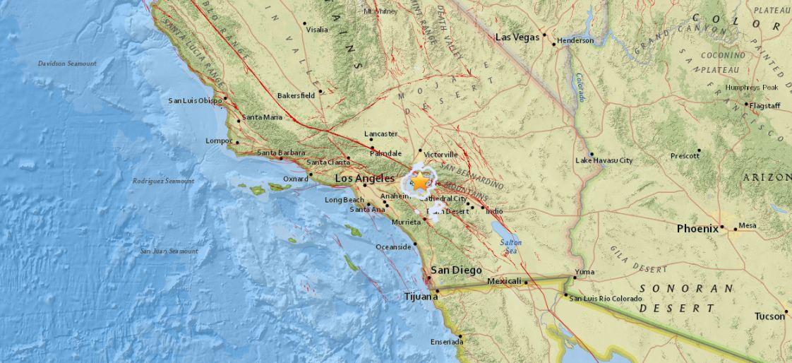
The quake hit at around 5:44 a.m. local time about 2 miles north of Colton, said the USGS.

Some on social media wrote that they could feel the quake.

An earthquake hit San Bernardino, California, on Sept. 20. (US Geological Survey)
“Earthquake tremor definitely woke me up,” said one person.
“I just love waking up too earthquakes in SB,” added another.
“There was a 3.4 earthquake in San Bernardino CA? That’s not even big enough to wake up the Meth addicts,” another person joked.
On Sept. 19, the USGS said that a 2.9-magnitude earthquake struck off the coast Malibu, California. There were no reports of damage or injuries, but a number of people on the USGS website reporting feeling the tremor.
And on Sept. 19, a 2.6-magnitude earthquake hit near Elmira, California, which is located near San Francisco, according to the agency.

‘Deep Creep’ Under San Jacinto Fault

A new study found that there has been a discovery of unusual behavior deep beneath the surface of the San Jacinto Fault in Southern California.
According to the Geophysical Research Letters in an Aug. 30 study, “Over the past 36 years, seismic stations have recorded the style of deformation from thousands of small earthquakes in the San Bernardino basin, California. Within this basin, many earthquakes below 10‐km depth show deformation that does not match what we expect for this region during the current period between large damaging earthquakes along the San Jacinto and San Andreas faults.”

“Rather than showing expected horizontal slip, many of these earthquakes show vertical movement. We use crustal deformation models to show that vertical movement can be produced in the basin if the northern portion of the San Jacinto fault creeps at depth; this portion of the fault is constantly moving rather than locked, like the San Andreas fault,” said the study.

They found that small earthquakes take place “to and between faults” might have a different style of deformation.

“This means that scientists should not use the information recorded by these small earthquakes in the San Bernardino basin to predict loading of the nearby San Andreas and San Jacinto faults,” scientists said.
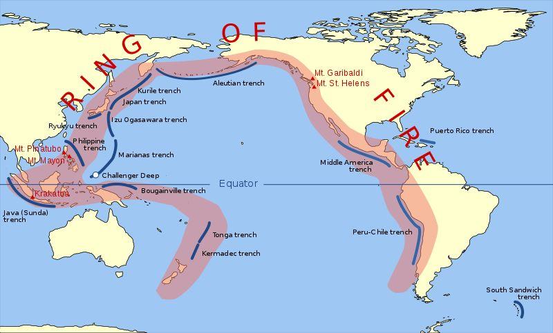
The Pacific "Ring of Fire." (Public Domain)

‘Ring of Fire’

California, like the rest of the West Coast of the United States, is on the “Pacific Ring of Fire,” the most seismically active region on earth. According to National Geographic, about 90 percent of the world’s earthquakes take place along the “ring of fire” and about 75 percent of the world’s active volcanoes are located there.

“The Ring of Fire isn’t quite a circular ring. It is shaped more like a 40,000-kilometer (25,000-mile) horseshoe. A string of 452 volcanoes stretches from the southern tip of South America, up along the coast of North America, across the Bering Strait, down through Japan, and into New Zealand. Several active and dormant volcanoes in Antarctica, however, ‘close’ the ring,” the publication stated.

Jack Phillips is a breaking news reporter with 15 years experience who started as a local New York City reporter. Having joined The Epoch Times' news team in 2009, Jack was born and raised near Modesto in California's Central Valley. Follow him on X: https://twitter.com/jackphillips5
twitter
Related Topics