Latest Update on Former Hurricane Leslie

Jack Phillips
10/14/2018
Updated:
10/14/2018

Former Hurricane Leslie, which is now a post-tropical cyclone after spending weeks in the Atlantic Ocean, is bringing rain and wind to Spain and Portugal, the BBC reported.

More than 15,000 people are without power amid the storm.

The remnants of the storm hit the central and northern parts of the Iberian Peninsula, CBS News reported. Portugal’s weather agency issued red alerts for high winds and dangerous coastal conditions over the storm.

Officials said the storm had 70 mph winds. A Category 1 hurricane has 75 mph winds, according to the Saffir–Simpson scale that categorizes hurricanes.

The BBC, however, noted that the storm had winds of up to 106 mph. Civil defense officials said that more than two dozen people were injured in Portugal.

A resident of the Figueira da Foz told a local news outlet, “I have never seen anything like it, The town seemed to be in a state of war, with cars smashed by fallen trees. People were very worried,” the BBC reported.

It is rare for such a storm to hit the Iberian Peninsula, and only five similar events have been recorded, the broadcaster noted.

The U.S. National Hurricane Center (NHC) said that a tropical depression formed just to the south of Mexico in the eastern Pacific Ocean.

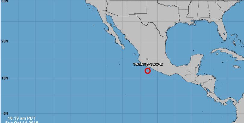
Tropical Depression Forms

The U.S. National Hurricane Center (NHC) said that a tropical depression formed just to the south of Mexico in the eastern Pacific Ocean.

“The depression is moving toward the west-northwest near 6 mph (9 km/h) and this motion is expected to continue today. A turn toward the west and southwest at a slower forward speed forecast to begin tonight and continue into Tuesday. On the forecast track, the depression is expected to slowly move away from Mexico over the next few days,” according to the agency.

It added: “Maximum sustained winds are near 35 mph (55 km/h) with higher gusts. Gradual strengthening is forecast during the next few days, and the depression is expected to become a tropical storm later tonight or early Monday.”

The NHC is monitoring two low-pressure areas as of Oct. 14. (NHC)

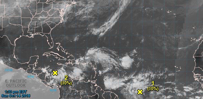
Elsewhere in the Atlantic

The agency also said it is monitoring an area of low pressure over the southwestern Caribbean Sea near Central America.
“The ”system has become better defined over the past couple of days. However, the surface circulation remains broad and upper-level winds are expected to be only marginally favorable for any development to occur while the system moves westward to west-northwestward over the next couple of days, reaching Nicaragua and Honduras by late Monday or early Tuesday,” the NHC said. “Regardless of development, locally heavy rainfall will be possible across portions of Central America Tuesday through Thursday.”

There is a 20 percent chance of the storm becoming a tropical cyclone in the next five days and a 10 percent chance of it becoming one in the next two days, the NHC said.

In the central Atlantic Ocean east of South America, there is a “broad, low-latitude tropical wave” located 800 miles east of French Guiana.

“Any development of this system should be slow to occur during the next couple of days before upper-level winds become unfavorable around mid-week, prior to the disturbance reaching the northeastern coast of South America,” the agency said, adding that there is a 10 percent chance of development into a tropical cyclone over the next two or five days, respectively.
Jack Phillips is a breaking news reporter with 15 years experience who started as a local New York City reporter. Having joined The Epoch Times' news team in 2009, Jack was born and raised near Modesto in California's Central Valley. Follow him on X: https://twitter.com/jackphillips5
twitter
Related Topics